Bogota and Central Colombia

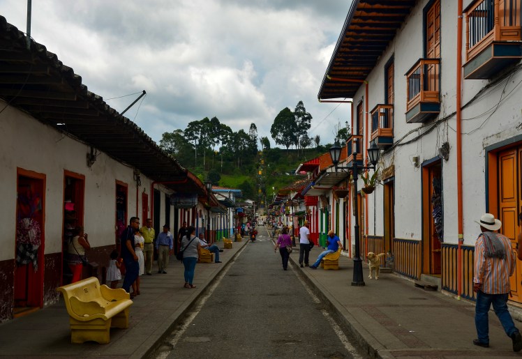
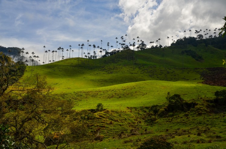
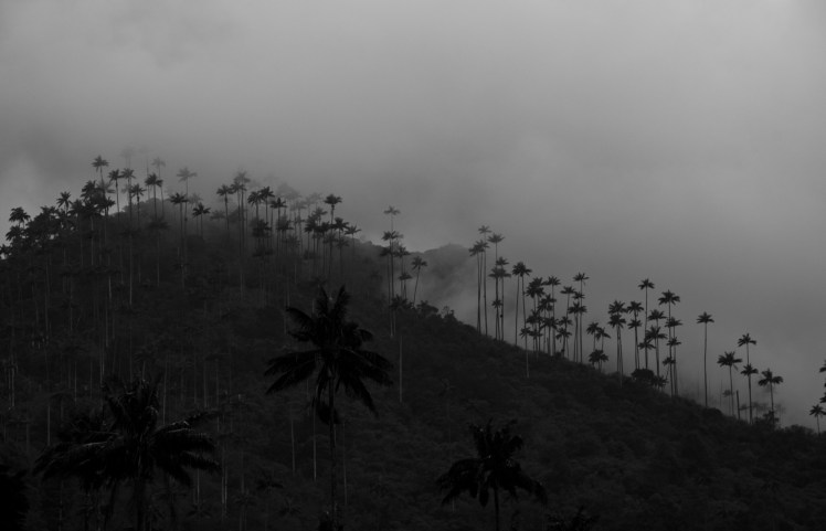
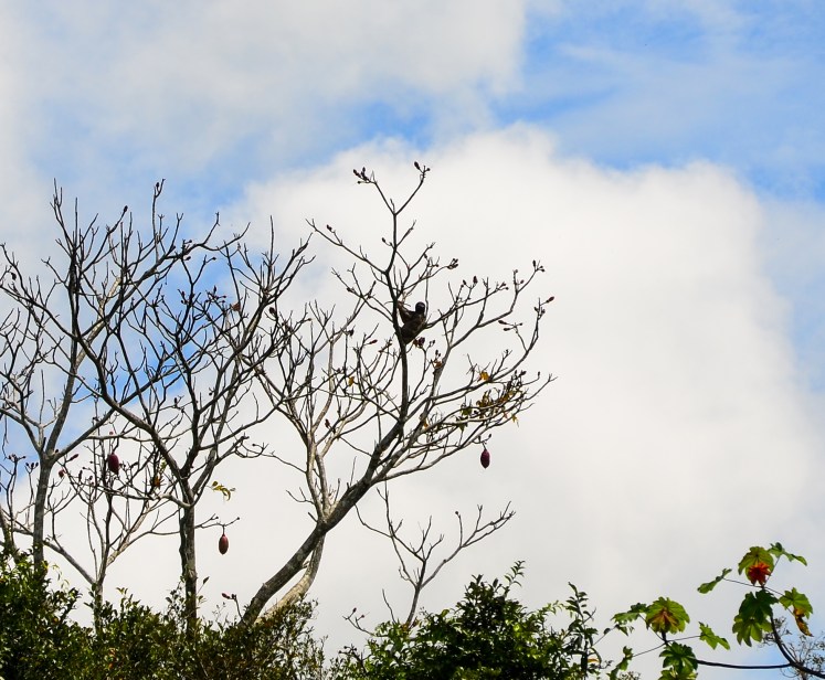
Salento was our next stop after Medellin. The town itself is quite attractive, although less so than Guatape, but both become overrun by tourists on the weekends. Salento is in the Zona Cafetera, an area full of lush green rolling hills and dotted with coffee plantations. Andrew mentioned that Colombia’s landscape facilitated narco activities, and seeing the terrain of this countryside made this fact even clearer, and this wasn’t even thick jungle. We took a tour of one of the smaller permaculture farms owned by a Spanish guy, and Andrew even had the first (and probably last!) two cups of coffee in his life. We played a couple of games of ‘Tejo’, which involves throwing a metal puck at a target which is filled with gunpowder. Good fun. The walk in the nearby Valle de Cocora gave views of 60m tall palms in the mist, which were unexpectedly eerie. I did not think that palm trees could have such a creepy presence.

DSC_6741 edit
Salento
DSC_6831 edit
Valle de Cocora

DSC_6780 editDSC_6894 edit raw B+W

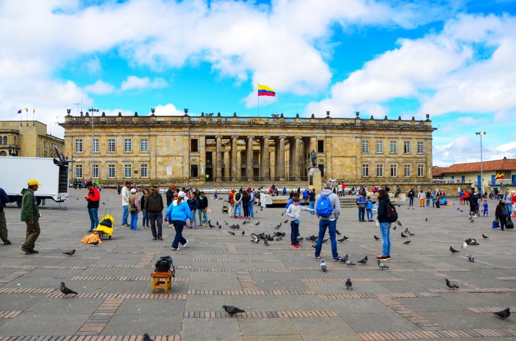
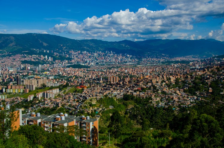
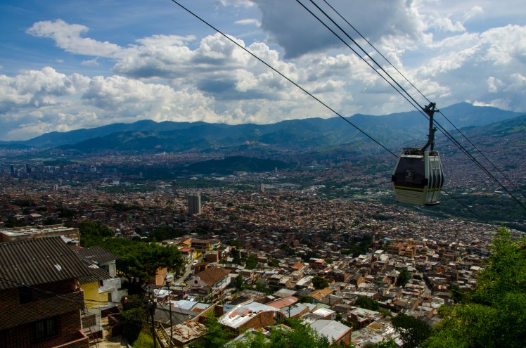
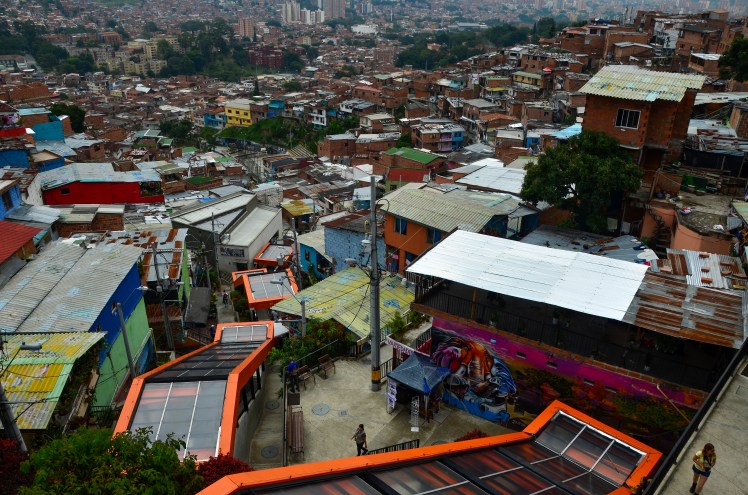
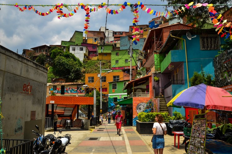
The marked inequality we had observed in Medellin continued to be evident in our next stop, Bogota. The city sits at 2600m above sea level and sprawls north to south, bordered by a short mountain range to its east. Wealth is a sliding scale increasing from south to north, which was obvious after entering the city from the south on the bus from Medellin. The surroundings slowly changed from cramped tin-roof housing to high rise apartment blocks and trendy bars. Further north from the historical centre (La Candelaria), is where the seriously wealthy reside. According to one measure of inequality, Colombia is the most unequal country in Latin America.

DSC_6354 edit
Plaza de Bolivar, Bogota

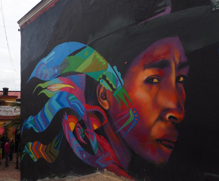
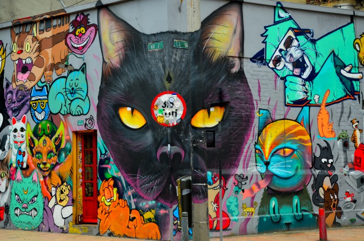
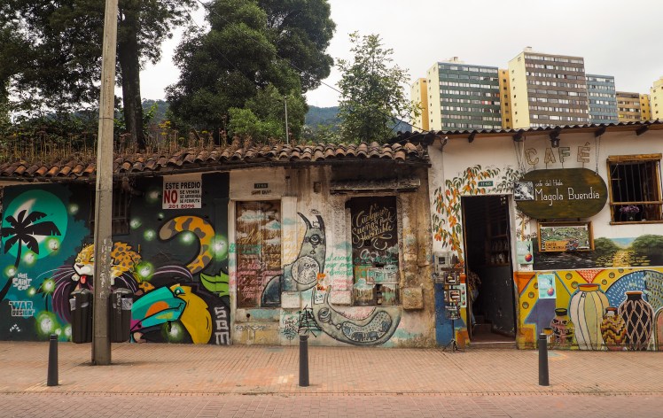
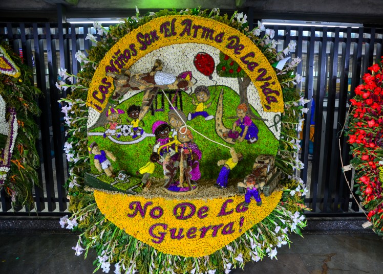
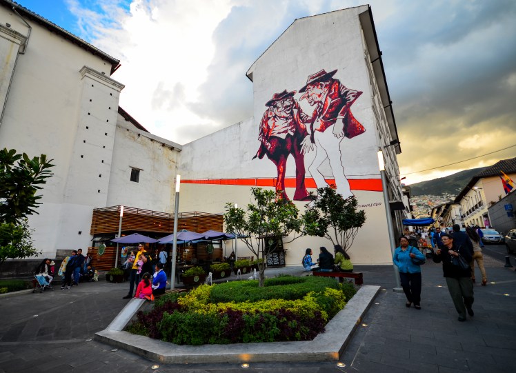
This inequality is a recurrent theme in much of the street art of which Bogota is famous for. After a young street artist was killed by police in 2011, who then attempted to cover up the crime, there was much public uproar. The government responded by relaxing laws surrounding graffiti, allowing the scene to flourish. Many pieces adorn the walls of La Candelaria and in downtown, with those in the latter region being more politically charged. Along with inequality, other themes include international corporations, the environment, indigenous culture and violence in Colombia.

OLYMPUS DIGITAL CAMERADSC_6293 editOLYMPUS DIGITAL CAMERA

The country’s bloodied history stretches back almost 70 years. Political tensions bubbled between liberals and conservatives in the first part of the 20th century, and when the popular liberal presidential candidate Jorge Gaitán was assassinated in 1948, it sparked a frenzied 10 hours of riots in Bogota (‘El Bogotazo’) and a civil war (‘La Violencia’), which lasted 10 years. One night in Bogota, I looked up some photos taken during El Bogotazo and it was crazy to imagine that such carnage had occurred on the very streets I had been wandering that day. La Violencia ended in 1958, however guerrilla and paramilitary groups continued to emerge. Towards the end of the 1970s, militant and narco activities became intertwined. Corruption was (and still is) rife. The 2000s saw the horrific ‘false positives’ scandal occur, in which thousands of innocent civilians were murdered by the military. The bodies were passed off as guerrilla fighters in an effort to increase the apparent success of the fight against these groups. There was a financial incentive for the military to report more killings.

DSC_6323 edit B+W

Colombia is hopefully on the cusp of a new era. In December 2016, a peace deal with the guerrilla group FARC was reached after lengthy negotiations and an unsuccessful referendum. The group finished handing over their weapons to the UN in June of this year. However, many citizens are not celebrating just yet. They fear that negotiation of the peace deal with FARC will not be the end of the trouble, and that other violent militant and guerilla groups will fight for control of previously FARC held land.

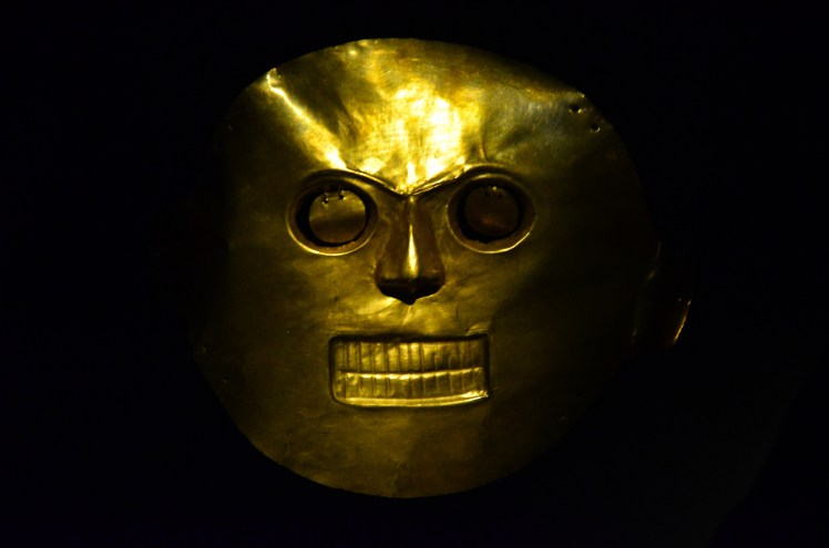
Whilst in Bogota we did a graffiti walking tour and visited the Museo de Oro (Gold Museum), which detailed the use of gold in the country in pre-Colombian times. One to two days would have been more than enough time spent in the city, however we spent a couple more than this as I had to navigate the somewhat frustrating Colombian health system. I needed to see a doctor about the reaction I had in the Amazon in May. We first tried to just show up at a couple of clinics at one of the hospitals, but it turned out it was a public holiday and none of them were open. Appointments could not be made online to most doctors, and of course the booking function on the website for one that did accept reservations was not working. I called a clinic to book, only to be told to call back in the morning and when I did, I was told again to call back in three hours because the receptionist couldn’t make appointments without the doctor there (what is the point of a receptionist?). Finally, we tried just turning up at a different clinic and I got in straight away, I think because I was paying cash whereas most Colombians use insurance. I felt very uncomfortable being called in for the appointment ahead of people who had been waiting before me. In the end, because EpiPens are not available in Colombia, we needed to be taught how to use a syringe and vile of epinephrine in an emergency. I have to say, the doctor I saw was excellent though, and the meds were only $4 AUD! I just wonder what the experience of Colombians is like in similar situations.

IMG_6314 edit
Parade for the anniversary of Bogota’s foundation
DSC_6334 edit
Creepy looking mask at the Museo de Oro

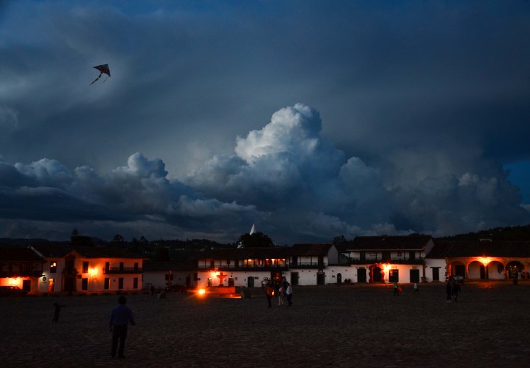
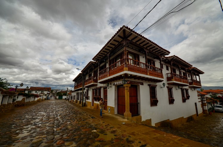
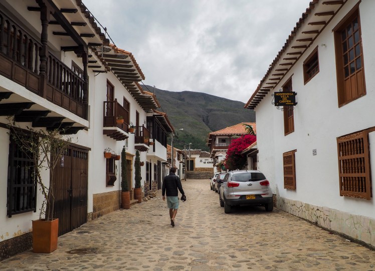
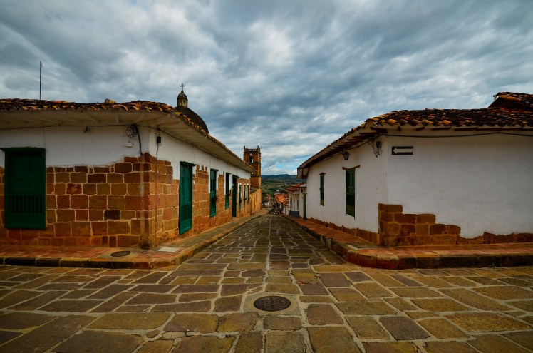
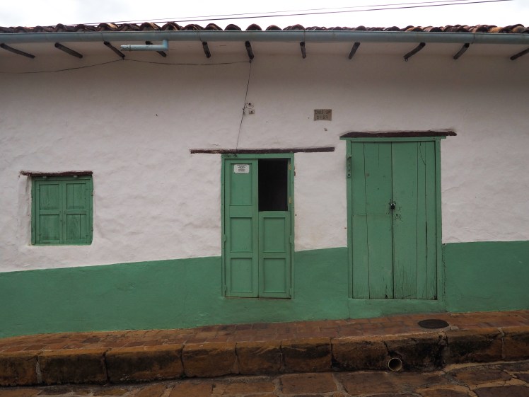
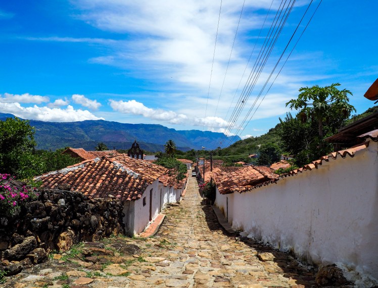
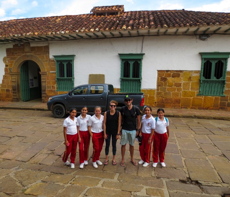
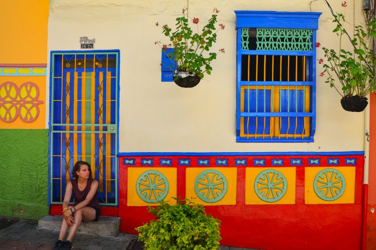
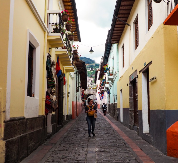
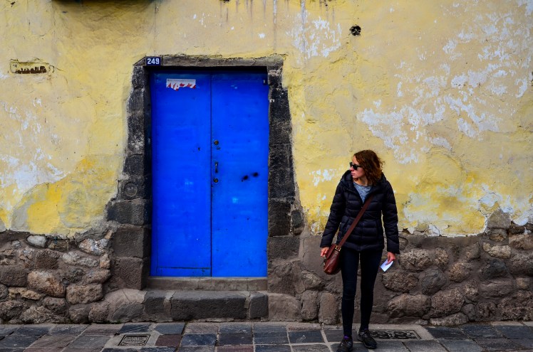
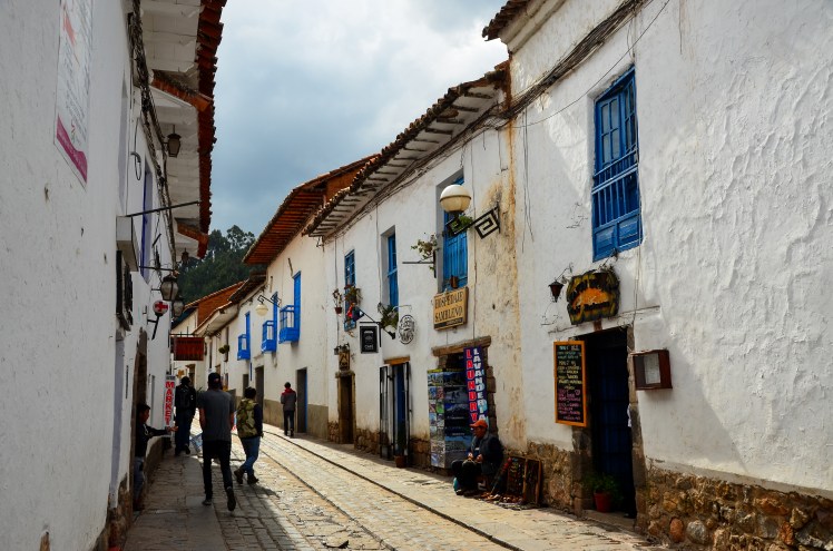
After finally leaving Bogota, we visited two lovely old colonial villages on our way to the Caribbean coast, Villa de Leyva and Barichara. Both reminded me of Sucre in Bolivia, although the colourfully painted front doors and window frames were typically Colombian. The local people of these two little towns were very friendly and although you can never generalise your experience with a handful of people as being reflective of an entire nation, friendliness has definitely been a theme in Colombia so far. I can only hope that the post-FARC strategy is well managed and that Colombian people are finally rewarded with the peace that they have been seeking for such a long time.

DSC_6897 edit
Massive Plaza Mayor in Villa de Leyva
DSC_6913 edit
Villa de Leyva
OLYMPUS DIGITAL CAMERA
Villa de Leyva
DSC_6992 edit
Barichara

OLYMPUS DIGITAL CAMERA

OLYMPUS DIGITAL CAMERA
Guane, a small village near Barichara
IMG_6367 edit
When school kids ask for a photo, you can’t say no (Barichara)

Erin

A City Reborn

Let’s be honest, the first thing that comes to your mind when I mention Colombia is drugs. This is understandable. A broken country after a long civil war, a landscape (huge swathes of jungle) perfect to conceal narco activities and an ideal location to influence both production and distribution of cocaine, media reports on Colombia over the past 40 years have almost entirely been concerned with the drug trade.

Given the reasons above, the fact that Colombia is constantly linked with the drugs trade is unavoidable. However, this stereotype is something that Colombians, most of whom aren’t involved in industry and many of whom have been either directly or indirectly exposed to the tragic consequences of the drugs trade, have to deal with regularly. It seems very cruel that those who have suffered the most from the criminal activities are those who are also suspected of being narco traffickers every time they travel to a different country.

Unfortunately, this outside perception of Colombia may not change any time soon. While the focus of the cocaine production has shifted towards Mexico, Colombia remains one of the leading producers. A prominent representation of Colombia in popular culture over the last couple of years has been the TV show Narcos. It’s not surprising that many Colombians passionately dislike the show.

DSC_6369 edit raw

This tragic history of the drug trade, and also how Colombians are perceived in the outside world are particularly important to understanding the experience of visiting Medellin. The second biggest city in Colombia was home to the most famous narco of all (Pablo Escobar), and had a murder rate reach as high as 381 per 100,000 inhabitants in 1991 (the highest rate in 2017 is Caracas in Venezuela, with 130 per 100,000), when it took the unenviable crown of being the most dangerous city in the world. Fast forward 26 years later, and Medellin was probably our favourite big city in South America, and we ended up spending 11 days there, despite there being no iconic ‘must-see’ sights.

DSC_6599 edit raw

DSC_6714 edit
Guatape

The surrounding countryside was very scenic, and we had an enjoyable day taking a bus out to the cute town of Guatape, with its colourful houses and impressive views. We spent a couple of days brushing up on our Spanish at a café near our accommodation, went to some salsa bars and indulged in several ice creams and brownies. We visited the Museum of Memories and did a couple of walking tours. We went to the Flower Festival, one of the biggest events in the city, which involved a parade with over 500,000 people watching. And like every other event with over 500,000 people involved, it was too crowded to derive much enjoyment, although the nearby supermarket handing out free beers was doing its best.

DSC_6361 edit
Feria de los Flores

DSC_6434 edit

Free beers aside, one major reason we loved Medellin so much was the people. In a lot of places around the world, tourists (often justifiably) are treated as either imposters or walking bags of money. Hoping to change the perception of their city globally, Medellin residents are happy foreigners are coming to learn more about their hometown and possibly even view the emergence of gringos as a symbol of how far the city has progressed. As a result, tourists in Medellin are made to feel more welcome than anywhere else I’ve been in the world. We were stopped numerous times in the street with people wanting to ask us where we’re from and welcoming us to their city.

And it’s not just that the people are polite. They all seemed so happy as well. It really says something of the resilient nature of humans that a city that was so devastated not all that long ago is now such a fun place to be. It really is contagious.

DSC_6440 edit raw

DSC_6503 edit
Escalators in Comuna 13

Indeed, the whole progression of Medellin from the most dangerous city in the world to now was uplifting to learn about. Before arriving in Medellin, I read that it was voted most innovative city in the world in 2013. My first thought was that they’ll hand out awards for anything these days. But the more time I spent in Medellin, the more I realised the city totally deserved it. Over the last twenty years, metro lines, cable cars and even massive outdoor escalators have been built, allowing greater access to the entire city for the poorer neighbourhoods. The installation of art and libraries in public spaces has transformed a lot of former no-go areas into places that can be enjoyed by all, and given those in poorer districts a greater chance at finding other career paths rather than falling into the narco trade.

DSC_6408 edit B+W
Parque de la Luz

Even neighbourhoods that had been outside of the government’s control, or just ignored by politicians, are being reinvented. Comuna 13, once the most dangerous district in Medellin is now full of colour and life, thanks in large part to passionate and courageous local activists who – particularly through street art and hip hop – are giving the children alternative ways (other than gangs) in which to feel part of a community.

DSC_6530 edit
Comuna 13

DSC_6427 edit

Colombia still has rampant inequality, and its location will always be desirable to drug producers and traffickers, so there is some worry that these improvements are only a temporary respite. But no matter what happens in the future, I’ll remember Medellin in 2017 as an incredibly uplifting place that against significant adversity displayed some of the best qualities that human nature has to offer.

Andrew

Isolation

After the 10 day Cedros – Alpamayo Trek I decided to do the Cordillera Huayhuash circuit. Erin was satisfied with the one long trek and chose not to join me. In order to save money and give myself a bigger physical challenge over 9 days, I did the trek unsupported.

With nearly the entire trek over 4,000m, passes above 5,000m and a complicated ticketing system, the day before leaving I started to worry if I’d gone a bit beyond my capabilities for my first solo hike. I need not have worried. The trek has become so popular in recent times that at no stage did I go more than a few hours without seeing someone, and the campsites leant more towards annoyingly loud than spookily quiet.

DSC_5753 edit
Campamento Huayhuash
DSC_5372 edit
Only campsite I got to myself

This hasn’t always been the case in the Cordillera Huayhuash. For years it was considered a no go area for tourists, with Shining Path rebels (a communist militant group) hiding out in the region. In 2004, a trekker was killed after an argument escalated with an armed local. Even as late as four years ago when my parents did the trek, they saw way less than the 30+ people I saw most days.

IMG_3865 edit
Laguna Sarapacocha
DSC_6178 edit
Laguna Jahuacocha

My feeling is the trek is only going to continue to get busier. It really does deserve its reputation as one of (if not the) best multi day walks in South America. Amazingly, the area is not a national park. This appears to have some advantages, as the fees I was charged to enter each of the different administrative areas went directly to the community, as opposed to first being diverted through the Peruvian bureaucracy. The negative aspect of this arrangement was also apparent early on during the trek as I walked past an operational mine.

DSC_5488 edit raw

DSC_5975 edit

DSC_5784 edit

Some parts of trekking solo were great. I could wake up when I wanted. Walk as far and as fast as I felt capable. Eat whenever I was hungry. There was also a lot of time where all I had was my own thoughts as I walked along. But towards the end, probably exacerbated by a river fall that damaged my camera, I started to struggle with motivation, or at least begin to question why I’d spent 23 of the last 25 days walking in the mountains.

Certainly, I won’t miss having the same meals nine days in a row. Opening the tent each morning was a nightmare, with the ice that had accumulated on the outside of the tent overnight finding its way onto my neck and back. I’ll be happy to not have to endure another night so cold that I’m in all my clothes, gloves and beanie cocooned in my sleeping bag and still freezing. I stank. I didn’t enjoy the continued thoughts popping into my head that when I re-entered society something bad may have happened to someone I care about. There is a large part of hiking that isn’t just mediocre, it’s downright horrendous.

That said, I enjoyed feeling like I deserved all the chocolate I was eating. On clear nights, the sky was amazing. I loved not hearing traffic for days on end. But most of all, I’ll miss the views that the Huayhuash circuit offered – often after spending hours struggling up a steep track. This is what makes it all worth it.

DSC_6005 edit raw
Paso San Antonio
Huayhuash Pano 5407
Laguna Carhuacocha
DSC_5627 edit raw
Mirador up Siula Pass
DSC_5962 edit raw
Yerupaja

In the end, I think the reason I struggled for motivation at times on this walk was the absence of Erin. It was a tale of two extremes, going from spending literally 24 hours a day together for most of the last 8 months, to having 9 days without any contact, the longest we’ve had in 11 years. And I didn’t enjoy it one bit. I guess it shows how important she is to me. Or maybe it highlights an unhealthy dependence.

Andrew

Walking the Cordillera Blanca

Andrew’s parents joined us in Quito soon after Ashley left and we spent the first few days researching last minute cruise options and then attempting to withdraw cash to pay for said cruise (Ecuadorian ATMs are not overly friendly). They kindly brought over some Tim Tams which was very exciting. As Andrew outlined previously, the Galapagos was an incredible experience. Leaving the booking to the last minute saved us a lot of money and if you are flexible with time and itinerary, I recommend doing it this way.

IMG_0780 edit
Bulk cash

After our time in the Galapagos we flew to Guayaquil, where we spent one night in the centre of town. Andrew and I had stayed here on the way up to Quito, but didn’t see anything as we stayed near the bus terminal. The waterfront area was pleasant and, strangely, there was a park full of iguanas in the centre of town! As we liked it so much the first time, we stayed in Huanchaco again to break up the journey south from Guayaquil to Huaraz. The town was equally as charming the second time round and it was great to spend a night in a proper bed between overnight buses. It also allowed us to visit the Temple of the Moon, an impressive ruin of the Moche people just outside Trujillo that we didn’t see on our way north.

DSC_2709 edit
Guayaquil
DSC_2803 edit
Original colours of the Temple of the Moon, built by the Moche culture (100-700AD)

We ascended about 3000m in altitude during the bus from Trujillo to Huaraz. The feeling after an overnight bus is never great, but the patchy sleep combined with the altitude gain left the four of us feeling sluggish. This first day in Huaraz was spent talking to many different tour providers to try and work out what trek we were going to do and whether we’d do it supported or by ourselves. More enjoyably, it was also the day we were introduced to Café Andino by Jan and Philip, who had frequented it when they were in Huaraz 4 years ago to do the Huayhuash trek. We hoped that walking up the staircase to the café would count as extra acclimatisation walks, although any benefits of the stairs were quickly undone by the delicious food and drink that was consumed.

Supported trekking is common in Peru, especially for the longer treks at high altitudes. In the end, we decided to do the 10 day Cedros Alpamayo walk with the same company that Jan and Philip had used in 2013. We wanted to see the famous pyramidal face of the Alpamayo peak (once voted the most beautiful mountain in the world), which is not seen from the far more popular 4-5 day Santa Cruz trek. The promise of less people also helped the decision.

DSC_4277 edit

We did 4 acclimatisation day walks of varying lengths and increasing altitude, which filled in the time well before the trek was scheduled to start. The first two walks were to Quechan named Lakes Wilcacocha and Uruscocha, and we finished our acclimatisation with 2 of the biggest tourist attractions in the area, Laguna 69 and Pastoruri Glacier.

DSC_3028 edit
Huascaran, the highest mountain in Peru
Laguna 69 Pano 3414
Laguna 69
DSC_3583 edit raw
Pastoruri Glacier

Acclimatisation is a must before starting a multi-day trek in Huaraz, as the passes can be close to 5000m and most nights are spent around or above 4000m. This means that most people spend more time in Huaraz than they would have otherwise. The city was tragically flattened by a massive earthquake in 1970, and as a result the architecture is not too inspiring. The traffic seems like it should belong in a larger city, not one of just 120,000 people. However, trekkers and climbers are going to flock to the area no matter what the city looks like. It is a base for two stunning nearby mountain ranges, the Cordilleras Blanca and Huayhuash, known for their 6000m+ steep snowy peaks, glaciers and picturesque turquoise alpine lakes.

Alpamayo Pano 5119
Cordillera Blanca

During our trek, our group consisted of the four of us and another couple from the USA. The 10 days would see us climbing 9 passes, the highest at 4860m, and covering around 130km. The nights were bitterly cold and we woke up to frost on the tent and frozen water bottles most mornings, but the days were sunny and clear. The scenery was incredible and we didn’t see many other groups on the trail until the second last day, when we climbed Punta Union pass (the main pass of the Santa Cruz trek).

DSC_4607 edit

DSC_3995 edit raw
Alpamayo

DSC_3820 edit 2

IMG_2760 edit

Not being the biggest fan of heights, I was a bit nervous about how I’d go on the passes. The altitude certainly made them more difficult, but I got through them all ok, albeit slowly. Neither the passes nor the altitude seemed to slow the Gatenbys down though! I had never done a trek this long before, which combined with the challenging nature of the walk and the amazing landscapes we saw left me with a real sense of achievement upon finishing.

DSC_4119 edit raw

DSC_4198 edit raw

IMG_2576 edit
Walking up Cara Cara pass on day 5

It was lovely to see Jan and Philip after 7 months on the road and we really enjoyed having them over here. When they arrived in Quito we only had a rough idea of what we wanted to do whilst they were here and didn’t have anything booked, but we managed to piece together a very fun and varied 6 weeks.

DSC_5001 edit

IMG_2998 edit
Samuel, Rudolfo and Miguel (our cook, arriero and guide)

IMG_2637 edit

Alpamayo Pano 4903
Punta Union pass

Erin

A Cost Benefit Anaylsis of the ACT and the Galapagos

I like numbers. They cut through biases and emotion and deliver the cold hard facts of a matter. So here’s a few facts for you:

  1. The number of bird species in the Australian Capital Territory (ACT) is 217, well above the 95 recorded in the Galapagos Islands.
  2. The number of different reptiles in the ACT is 52, compared with 39 in the Galapagos.
  3. There are 33 land mammals in the ACT. In the Galapagos, there are only 6.
  4. Including flights, the cost of entering the Galapagos marine park is roughly $520. The cost of visiting Namadgi National Park in the ACT is less than $10.
DSC_2335 edit
Blue-footed booby

The question must therefore be asked. Why is the Galapagos so famous as a wildlife area when the ACT has more animals and is much cheaper? There are really only four possible reasons why.

DSC_1150 edit
Galapagos sea lion
DSC_0655 edit
Isla Sombrero Chino
  1. Darwin

As most of you would know, English naturalist Charles Darwin’s observations during his trip to the Galapagos heavily influenced his bible of Atheism, On the Origin of Species. Maybe this is why far more people choose to view wildlife in the Galapagos than the ACT.

One species that was central to Darwin’s observations was the now named Darwin Finch. Only one species of Finch settled in the Galapagos, and Darwin observed that on each island the Finches had adapted differently. As of today, there are now 17 different species of Darwin Finch on the islands.

I saw hundreds of Darwin Finches while in the Galapagos. When Darwin sees Finches, he sees an idea that will revolutionise humankind. When I see Finches, I see a lot of skittish birds that look the same. And then I feel stupid.

Analysis: Darwin is not a reason that the Galapagos is a better wildlife destination than the ACT

  1. Surfing

Maybe I had it wrong from the start, and it’s not the animals but the quality surfing spots scattered around the islands that make it such a famous tourist destination.

These waves, however, aren’t breaking close to towns, so it’s probably over an hour for you to organise a water taxi and start surfing. There are quality surf spots only two hours from the ACT, and you don’t need a combination of flights and then a boat to reach them.

DSC_2606 edit raw

DSC_1563 edit

Analysis: It is not reasons other than wildlife why the Galapagos is a more famous travel destination than the ACT.

  1. Endemism

The Galapagos Islands were formed by volcanic eruptions in the ocean and at no stage in their history have they shared a land border with anywhere else. This means that all species that have made it to the Galapagos have had to make a difficult journey by air or sea. It also means that those species that have made it to the archipelago have developed and evolved in isolation. The result is that a significant number of species are endemic to the islands. The ACT currently shares a land border with New South Wales and has no endemic species.

DSC_1170 edit
Marine iguana

Ok, now we’re getting somewhere. Seeing endemic species is pretty cool. And unlike the Amazon, where you have to sneak around like a thief to see anything, these animals are just as likely to walk towards you as you are towards them. In our 10 days in the Galapagos we saw all the famous endemic species: Giant Tortoises, Galapagos Land Iguanas and Marine Iguanas. We also saw countless endemic birds.

DSC_0967 edit
Giant tortoise

Due to the nature of migration to the Galapagos, most of the land species are reptiles. And this was my only issue with land animal spotting. Reptiles are pretty boring. Mostly they hang around sunning themselves. The Iguanas in particular, once you’ve seen a couple of them, you feel like you’ve seen them all. The Giant Tortoises are a little bit more spectacular – they really are enormous and also it’s incredible to think how old some of them are. But even still I can’t imagine anyone wanting to spend more than an afternoon viewing them.

Analysis: The endemic species are a valid reason why the Galapagos is a better wildlife destination than the ACT, but not if it’s the only reason to visit the Galapagos.

  1. Marine Life

Things you are likely to see underwater in the Galapagos: Penguins, Sea Lions, Sharks, Sea Stars, Octopus, Coral, Colourful Fish, Sting Rays, Orcas, Manta Rays and Sea Turtles.

Things you are likely to see underwater in the ACT: Disease, Carp and for half the year, hypothermia.

Going into our Galapagos cruise, I was aware of the Darwin history and all the endemic animals on the islands. What I wasn’t prepared for was how amazing the snorkeling is. Located on the equator, it has all the colourful tropical fish that you’d expect, but importantly, two cold water currents that hit the islands bring penguins, whales and giant rays.

Penguin edit
Galapagos penguin
DSC_2058 edit
Mustard rays

The major decision we had to make during our time in the Galapagos was whether to do a cruise or a land based tour. We ended up doing a mixture of both, spending three nights on the islands after a week-long cruise. The final three days were enjoyable, but every non-cruise experience further vindicated our decision of going on a cruise. You get to visit places that are only accessible to the cruise ships, including the isolated western side of the islands, where we saw an Orca really close up and also an enormous Manta Ray.

DSC_9094 edit
Orca
DSC_9001 edit
Giant manta ray

And it’s not just the number of species that you see underwater that’s great, or the crystal clear water, it’s how close you can get to animals and their curiosity that really made snorkeling in the Galapagos so enjoyable. Scenes such as a penguin 30 centimetres from my mask engaging me in a staring competition, a sea lion doing backflips for fun right in front of me, or a white tipped reef shark leaving an underwater cave effortlessly propelling itself through the water are things that I’ll not forget for a long time.

shark edit 2
Whitetip reef shark

We ended up snorkeling more than 10 times on our trip, and it felt like there was something new to see each time. I’d never really seen the attraction of snorkeling before. Looks like I’ll need a trip to that big reef when I get back to Australia…

Analysis: The Galapagos is pretty great

DSC_2194 edit
León Dormido
DSC_0576 edit
Galapagos fur seal
DSC_1636 edit
Galapagos sea lions
DSC_8543 edit
Green sea turtle

DSC_2266 edit

DSC_1552 edit
Marine iguana
DSC_1532 edit
Flamingo
DSC_1324 edit
Galapagos penguin
DSC_0132 edit
Brown pelican

Andrew

An Ecuadorian Reunion

I thought I had well and truly grown out of being capable of the kind of excitement that children have in the lead up to Christmas, but the anticipation before Ashley’s visit felt just like that. It had been about 1.5 years since we’d last seen each other, and Ashley and her cousin Jess were due to get to the hostel at about 1:30am. I decided that I’d stay up and wait for them, but the periodic waves of adrenalin and also being almost 30 ruined this romantic idea, and by 12:30am I couldn’t resist bed any longer. Only 20 minutes later there was a knock on the door and there they were! It was a very surreal and happy moment.

Despite having been in transit for a day or so and arriving in a city that sits at 2850m above sea level, both Ashley and Jess were up and about bright and early the next day for our trip to Otavalo. It was amazing they were so fresh, I felt like a truck had hit me just for staying up past midnight. Otavalo is a small town about 2hrs bus drive north of Quito and is famous for its giant market. Although it is held every day, the biggest day is Saturday and this was conveniently when we were able to go. If Ashley visiting was like Christmas, then going to one of the biggest markets in South America was like waking up on Easter Sunday ready for the Easter egg hunt.

Within minutes of arriving, Ashley and Jess bought heavy and impractical Ecuador-themed drink bottles, and this was followed up by a purchase of matching colourful shorts for the three of us. Safe to say we gringoed the hell out of that market. We made sure to get back to the hostel in Quito in time for craft beer happy hour, which meant there were a few sore heads for our travel day to Latacunga the next day.

DSC_7328 edit
Otavalo market
DSC_7323 edit
Coffee break
shorts
$5 market gems

Latacunga is the city where most people base themselves for the Quilotoa Loop, a 2-4 day trek through the countryside in the district of Cotopaxi that is said to be one of the top things to do in Ecuador. There wasn’t much planning required – the walk goes through small villages and hikers stay in hostels along the way so we didn’t need to do any food prep or hire any gear. Not really much of a loop, you can start the hike in a little town called Sigchos (2800m) and finish at Quilotoa (3800m), or vice versa. We chose the former as although there is more climbing this way, we wanted to save the Quilotoa crater lake until last. It is always nice to have the promise of amazing views for motivation during a walk.

The hostel we stayed at in Latacunga had given us a page of instructions for the trek as the path is not well signposted. Initially this seemed like an excellent gesture, but the grainy black and white photos and vague comments such as ‘after some minutes you will come to…’ proved a little difficult to follow. Getting lost on the Quilotoa Loop is part of the experience it seems, and we had a few confused moments and unintentional detours along the way. Thankfully the locals were all very happy to help out with directions.

On day one we walked a few hours from Sigchos to Isinlivi, past green pastures and numerous cows. We stayed in a quaint little hostel with views of the valley and a llama, and helped some local children carry sacks of potatoes up the hill to their house. From Isinlivi we had about a 5 hour walk to Chugchilán, winding through the valley and ending with a climb to the road leading to the village. The hostel here was also excellent, and we enjoyed a beer with some pretty interesting travellers.

DSC_7374 edit

DSC_7404 edit
Valley views on the way to Chugchilán

Day three was the longest and the most impressive. We passed through a small village and it was disappointing to see some of the other hikers give lollies to the local children. The path slowly wound its way up and we found ourselves standing on the rim of the Quilotoa crater looking down into the enormous turquoise lake. After another hour walking around the rim, we arrived in Quilotoa village. We were very lucky to get the view we did at the top, as the clouds came rolling in as we approached the village. The next morning, we went kayaking on the lake before returning to Latacunga.

OLYMPUS DIGITAL CAMERA
Ashley and Jess walking along the side of the valley on day three
DSC_7456 edit
Quilotoa caldera
IMG_6052 edit
Kayaking on the lake

Our next stop was Mindo, a small town in the cloud forest north west of Quito. The bus from Quito dropped us at the exit to Mindo on the highway, at which time it began to pour with rain. We missed the only taxi that was there, but thankfully there was a bus stop to take shelter under. Whilst waiting there, a friendly man began talking to us in Spanish and explained that he had a hostel in town that we could stay in. I initially responded to this offer with more than a little internal scepticism, but he turned out to be incredibly helpful. His car had broken down so he had called a taxi which he let us take instead, and told us to have a look at his hostel and if we didn’t like it then that was just fine. After meeting his adorable wife and taking a look at the rooms, we were sold. We were basically staying in the couple’s house (their room was next door to ours and we shared a bathroom with them), and felt a bit like their children.

OLYMPUS DIGITAL CAMERA
Our lovely hosts

Mindo has a very interesting mix of expats, tourists and locals and quite a relaxed feel. We only had time to stay two nights, but I could have stayed longer. We spent our time there doing a chocolate making workshop, a walk to seven nearby waterfalls and ziplining. I had never ziplined before, and being scared of heights I was a little nervous to begin with. It was actually a lot of fun and I was glad that the others decided not to mention that a US tourist had died ziplining in Mindo a few years ago.

DSC_7654 edit
Mindo waterfall

It took a full day to reach the coastal fishing village of Mompiche from Mindo, a distance of only 325km. Such is the frustrating nature of the Ecuadorian bus system. Our days in Mompiche were pretty much structured around when we could have our next batido (smoothie). I think one day we had three each. This was mixed in with reading in hammocks, sleeping in hammocks, walking along the beach and sampling the local specialty ‘encocado’, a dish of seafood served in a delicious coconut milk sauce.

DSC_7660 edit
Mompiche fishing boats
OLYMPUS DIGITAL CAMERA
Watching the sunset in Mompiche

Another travel day got us back to Quito, just in time for craft beer night again. It seemed appropriate to end Ashley’s visit the way it started. One her last full day we explored the Old Town and had lunch at the market.

DSC_7968 edit
Plaza de la Independencia, Quito
DSC_8131 edit
Basilica, Quito
DSC_8147 edit
Quito streets
OLYMPUS DIGITAL CAMERA
Ashley walking down La Ronda, Quito
OLYMPUS DIGITAL CAMERA
Ashley and Jess strolling through Old Town
OLYMPUS DIGITAL CAMERA
Lunch haul at the market
quito edit
Quito skyline

There were some teary goodbyes that night. It was a great couple of weeks and Andrew and I really appreciated the visit by both Jess and Ashley. Hopefully I don’t have to wait another year and a half for my next Christmas.

Erin

On the road from Lima to Quito

I admit I was fairly happy to hop on the plane and say goodbye to Iquitos and the jungle. It definitely wasn’t the experience I’d hoped for! Anyway, these things happen. We had about a week to get from Lima to Quito to meet Ashley and Jess who were arriving late on the 2nd of June. This was a great opportunity to see some of Peru’s northern coast. Lima was nothing special but an okay spot for 24 hours. Like most tourists, we stayed in the Miraflores area. Lima is bathed in a grey glowing haze for many months of the year thanks to the Humboldt ocean current. It teases both imminent sun and rain, both of which rarely materialise. I found this to be quite depressing and would never be able to live there for this reason.

DSC_7055 edit
Dreary Lima
DSC_7062 edit
Grey skies of Lima

A 5 hour day bus got us to Barranca, where we stayed as a base to visit Caral, an ancient archaeological site. The big blue signs that indicated archaeological sites dotted the barren landscape north from Lima, and this also continued after Barranca. The Caral site is dated at approximately 2600 BC and is a construction of the Norte Chico civilisation, believed to be the first civilisation of the Americas (although not the first culture, there is evidence of human occupation much earlier than this). After reading ‘1491’ by Charles C. Mann, I was very keen to visit this region of Peru. The book states that this early civilisation has not received the recognition it deserves, and that pre-Columbian America was more advanced than previously thought.

The Caral ruins are not the oldest in the area (this title belongs to nearby Huaricanga, also a product of the Norte Chico people and dating back to 3500 BC – older than the Egyptian pyramids), however they are believed to be the largest. I find it fascinating that archaeologists have found no evidence of war or violence at Caral.

DSC_7081 edit
Caral

DSC_7123 edit

Aside from seeing Caral, we enjoyed the cheap benefits (such as $3 menus of the day) of being off the tourist trail in Barranca. From here, we booked an overnight bus to Trujillo. Turns out that it wasn’t so much an overnight bus as it was a bus that happened to run at night. It was a lot shorter than we’d been told, which possibly had something to do with the driver going 130km/h for most of the journey up the Pan Am highway. It was difficult to sleep, largely due to the strong stench of feet wafting through the cabin, and for Andrew because his legs were wedged into the reclined seat in front of him and he couldn’t move. We arrived in Trujillo at 2:30am and decided to see if we could get into our room early at the hostel we’d booked in the nearby beach town of Huanchaco. Great success. After enjoying an extra few hours of sleep in a bed that we had not expected to have, we spent the rest of the day relaxing by the sea and visiting the Chan Chan ruins. Chan Chan is the largest adobe city on the continent and was constructed in approximately 850 AD by the Chimu people, who were defeated by the Incans in the late 1400s. The architecture was very different to the Incan ruins we had seen.

DSC_7233 edit raw
Huanchaco pier
DSC_7228 edit
Reed fishing boats in Huanchaco

DSC_7240 edit B+W

DSC_7175 edit
Chan Chan

IMG_6003 edit

After another overnight bus, which also travelled at ridiculous speeds but didn’t smell quite as bad this time, we arrived in the coastal town of Mancora, which felt like Huanchaco’s younger and drunker sibling. It’s louder, bars line the beach and a walk down the main street involves being approached by hordes of insistent mototaxi drivers offering their services. The beach at Mancora is a lot prettier, but we much preferred the laid back fishing village feel of Huanchaco. Mancora was, however, a good way to break up the journey and get in some beach time before our next bus crossing the border to Guayaquil in Ecuador.

DSC_7261 edit
Mancora beach
DSC_7306 edit
Mancora sunset

This border crossing has a bad reputation, so we made the journey during the day. We didn’t see much of Guayaquil as we stayed near the bus terminal and took our final bus to Quito the next morning. The advertised 8 hour journey actually took 10, which seemed like an appropriate way to finish the week long bus trip north.

Erin

Welcome to the Jungle

Tourists come to Iquitos for two reasons. Ayahuasca (a hallucinogenic plant taken by many to find themselves) and the Amazon basin. It can be a fun game to play before you start talking to another tourist, Ayahuasca or Amazon? The fifty year old couple with their DSLRs around their neck and the 55kg males with 35 ankle bracelets made particularly easy guesses.

Iquitos is also the largest city in the world inaccessible by car and exploiting resources has been a constant theme throughout its history. It was a rubber boom of the early 19th century that put the town on the map, and major industries today include petrol, timber, fishing and hunting. And tourism.

Indeed, a slight bit of research into tourism in Iquitos leads you down a rabbit hole of fake guides, “jungle” lodges that aren’t much past the outskirts of a major (500,000 people) city and poor treatment of animals. Many guides have no issues taking sloths out of trees, and animal centres cage rare creatures in horrible conditions, all in the hope that a few gringos will pay a bit of money to get a good photo (#amazingwildlifeexperience).

DSC_6077 edit
Sloth

During our research we stumbled across an Amazon lodge that was very passionate about conservation of the Amazon ecosystem. The owner, Katoo, worked incredibly hard in ensuring his plot of land was as pristine a jungle as possible, and this meant spending countless hours fighting the hunters and loggers that frequently trespassed onto his property. The other attraction of this lodge was that it was located very deep in the jungle, with the understandable catch that the tours were significantly more expensive. We decided to spend the money.

IMG_5797 edit
Nanay (black water) meets Amazon (brown water)

We spent our first day in Iquitos trying to adapt to the 1000 per cent humidity and also paid for a small boat to take us to the actual Amazon River, something that had been the determining factor in us choosing Iquitos for our jungle fix over the Amazon basin tours offered in Southern Peru. The next day, we spent most of the day travelling around 8 hours first by bus, boat and then another boat to get to the Tapiche Lodge, which was to be our home for the next four nights.

DSC_6284 edit

The first sunset of the jungle trip was spectacular. Lying on a boat, the sun lighting up both the sky and the river. Listening to birds calling, monkeys howling and watching the pink and grey dolphins circle around us. Surely it doesn’t get any better than this, I thought to myself. Unfortunately, it didn’t.

The next day started out in a similar vein, canoeing through small creeks viewing different bird species and the occasional monkey. After a couple of hours in the canoe, our guide Katoo decided it was time to explore the jungle on foot. This was when the problems started.

DSC_6795 edit
Black Caiman

We had been warned about the mosquitos in the Amazon, and while on the boat and at the lodge they hadn’t been too bad. But as soon as we left the canoe to walk through the thick jungle, swarms of them were following us.

I thought I’d had it bad with the mossies on this walk (and the next day I counted over 20 bites on my left hand) but when we returned to the boat and I looked at Erin, I could see that she had fared considerably worse, with a number of quite large bites already forming on her forehead.

These lumps on her forehead continued to increase, and after returning to our lodge it was pretty clear they were not mosquito bites. After discovering more lumps on her lower back, we wondered if it was bed bugs. But as the rash began to spread to her face it was pretty clear it was some form of allergic reaction.

DSC_6594 edit

DSC_6354 edit
Tapiche Lodge

Our lodge had only basic medical supplies and expertise (including a suggestion from one of the workers for Erin to put sugar mixed with water on her skin and take a shot of apple cider vinegar), and was 3.5 hours from the closest hospital. Even an anti-histamine didn’t stem the tide as the rash continued to spread over Erin’s body. Her ears and more worryingly her throat started to swell.

A nervous half hour followed and when Erin realised that the swelling in her throat had worsened, we decided it was time to get to a hospital ASAP. The 3.5hr trip to the hospital wasn’t without incident, with the engine stalling and unable to start for 15 minutes. Luckily by this stage Erin’s throat had stopped swelling, so I was less worried she was going to choke to death and now only concerned that we may have to spend a night outside in the middle of this mosquito infested river.

DSC_6368 edit

Our driver was able to start the boat again and managed to navigate the last hour of the trip in the dark with only my phone to light the way, and we arrived in the river town of Requena. The limited facilities at the hospital were eye-opening, but after visiting a couple of different pharmacies and Erin getting an injection, her rash and swelling finally started to abate and we could relax.

Given we had no idea what had caused the allergic reaction, and as the lodge was so isolated, Erin decided not to return and instead made her way back to Iquitos. I made the trip back to the lodge, determined to enjoy the last few days of the jungle given we’d spent so much money on the tour. Things didn’t get off to a good start when I heard a guy from another boat whistle in our direction and when I turned I saw him lift his rifle and point it at the boat. I’m not sure if this was a joke or a threat. Maybe he was mates with my driver. Maybe he’s one of the many hunters who hates Katoo and recognised his boat. Whatever it was, it didn’t do anything to help my enjoyment levels.

DSC_6911 edit

Thankfully, things settled down after this. Erin made it safely to Iquitos, and I was able to enjoy the last two nights in the jungle. There was more floating down rivers while listening to the sounds of the jungle. More species of animals and birds to see. More mosquitos.

DSC_6633 edit
Squirrel Monkey

In an earlier blog Erin mentioned the impact of expectation on experience. And there is nothing that increases expectations more than money. While I enjoyed my stay in the heart of the jungle, I didn’t love it – which was probably what the money required. I don’t think my view would’ve changed if Erin was able to stay the entire time. And I don’t think it was the fault of Katoo and the Tapiche Lodge, who are doing a great job under difficult circumstances to preserve the fragile eco-system. In the end, I think I just rather mountains and coastline than jungle. It’s not you Amazon, it’s me.

Andrew

DSC_6395 edit
Jabiru Stork

Salkantay and the Sacred Valley

Despite there being a lot of annoying tour operators in Cusco’s Plaza de Armas, one of them actually came in handy when organising the Salkantay trek. We were planning on doing the trek independently, but doing the sums we realised it wasn’t going to be much cheaper than booking with a guided group, which is how most people do it. The minimal difference in cost plus the added bonuses of not having to cook, set up a tent or carry all of our stuff made the decision for us. The van picked us up about 5:30am and after a breakfast stop along the way, we arrived at Challacancha, the starting point of the walk.

Apart from 30min of uphill at the start, the walk to the campsite at Soraypampa was flat. The sun was shining and Mt Humantay made an excellent backdrop to the walk. As we approached the campsite, Mt Salkantay came into view. It was such a picturesque camping spot. After a massive lunch, we walked up the hill to Laguna Humantay at the base of the mountain. The water and the wall of mountain behind it were stunning. I found a nice little rock to sit on and take it all in. That night was pretty chilly as the campsite was at 3,920m.

DSC_4962 edit raw
Salkantay
DSC_5056 edit
Laguna Humantay

Salkantay Pano 5011

Day two involved walking up to the Salkantay pass (4,630m) and then descending to Chaullay (2,900m), where we camped. Everyone in our group was apprehensive about the pass, and it definitely wasn’t easy, but with regular breaks and a slow and steady pace we made it to the top without too many difficulties. Clouds crept in but we were lucky enough to get a glimpse of Laguna Salkantay.

IMG_4509 edit
Top of the pass
DSC_5206 edit
Last glimpse of Salkantay before it disappeared 

The walk from the pass to Chaullay was similar to the first day of the Choro trek in Bolivia, and once again I enjoyed seeing the landscape transition from alpine to rainforest with the decreasing elevation.

The scenery on day three wasn’t as varied and we walked a lot of the day on the road, arriving at our camping spot in Santa Teresa mid-afternoon. We visited the nearby hot springs which felt like a very luxurious thing to be doing in the middle of a trek! The first half of day four was not that interesting, as we continued walking along the road to Hidroelectrica. After lunch, the walk along the train tracks to Aguas Calientes was a lot more enjoyable, and we could see glimpses of Machu Picchu high up on the ridge above us. We stayed in a hostel and found it strange to be enjoying the comforts of showers and wifi while we still had more hiking in coming days.

DSC_5384 edit B+W

Our alarms sounded bright and early on day five and we left the hostel with the group at 4am. Our guide had advised us to get to the gate at the base of the climb to Machu Picchu as early as possible. It opened at 5 and after a 45min stair climb we made it to the entrance. Our first sight of the ruins was very different to the one we had three years ago after hiking the Inca Trail. This time it was perfectly clear and the snow-capped Pumasillo mountain was visible in the distance. As the sun rose, the stone buildings were slowly illuminated and the Urubamba river could be seen in the valley below.

DSC_5534 edit raw

IMG_5626 edit
Temple of the Sun, Machu Picchu

We had a 2 hour tour from our guide and then spent a few more hours exploring the main site and walking to the Sun Gate and the Inca bridge. The amount of tourists increased throughout the morning as people arrived by the bus load. It was almost impossible to get a photo without someone walking into it, which certainly takes away from the serenity of the ruins.

DSC_5512 edit raw
View from the Sun Gate
IMG_5665 edit
Steep drops on the way to the Inca bridge

DSC_5676 edit

A few people have asked us if we preferred the Salkantay or the Inca Trail. The first two days of the Salkantay are stunning, whilst the Inca Trail passes other ruins and enters Machu Picchu more dramatically through the Sun Gate. There is an option to combine the two treks by starting the Salkantay and branching off to join the Inca Trail just before the pass, which I think would be the perfect mix.

After Machu Picchu, we stayed another night in Aguas Calientes (2 nights were more than enough in this cute but soulless tourist town) and walked back to Hidroelectrica the following day. The bus from there to Ollantaytambo in the Sacred Valley was a 4hr trip on a narrow road that was at times carved into the side of a steep mountain. An impressive Incan fortress overlooks the pretty Ollantaytambo village, and this was the site of the only victory the Incans had against the Spanish.

DSC_5861 edit raw
Ollantaytambo

Avoiding pricey tours, we took a local collectivo and a shared taxi to see two other Incan sites in the area – Moray (believed to be used for agriculture experiments) and Salinas (terraces cut into the hill side to extract salt from the water). We stayed in nearby Pisac and spent the next day exploring the ruins up on the hill and browsing the giant market in the main square.

DSC_5876 edit raw
Moray
DSC_5903 edit
Salinas de Maras
DSC_5933 edit
Pisac
DSC_5990 edit
Temple of the Sun, Pisac

Returning to Cusco a week after we had left for the Salkantay trek, I felt we had learnt a lot more about Incan beliefs, architecture and their clashes with the conquistadors. We had visited the Incan museum in Cusco, but it was not until we stood in front of their incredibly well-constructed buildings situated in the most unlikely and seemingly inaccessible places that we realised just how impressive both the structures and their empire was.

Erin

Inca Inc.

The capital and centre of the Incan Empire, close to 6,000m peaks, Amazon jungle and the gateway to one of the seven wonders of the modern world, Cusco is a city on the itinerary of almost every traveller to South America.

For us, soon to depart for coastal and jungle environments, it felt like the end of a significant chapter in our trip. The culmination of over two months of Andean culture and mountain scenery – with the grand finale in arguably the most famous Andean city of them all.

I found Cusco to be underwhelming. It’s a city based almost entirely around tourism, and it feels like everyone in the city centre is trying to get their piece of the tourist pie. This has resulted in a proliferation of tour agencies. A small number of companies actually administer the trips, but you can buy them from small shop fronts all over the city.

DSC_6022 edit

This sounds convenient in that you’re never far away from a place to organise one of the many great tours offered from Cusco. In actual fact it’s just incredibly annoying having to respond to every third person you walk past that no, you don’t want to go to Machu Picchu with them. And that no, you don’t care they have a special price.

When you add to this a bunch of people selling you artwork, offering massages, or trying to get you to eat at their restaurant, you get the Plaza de Armas in Cusco. This plaza has the honour of being both one of the nicest looking and also one of the least enjoyable main squares across all of South America.

DSC_6020 edit

It’s hard to not get frustrated or rude when dealing with these sellers, but the reality is they are just doing their job – and in Cusco tourism is probably the best way to earn a living and support your family. We tried to remain as nice as possible while saying “no gracias” to all these approaches, but it gets difficult when you’re asked by three different people during a five metre stretch if you would like a massage.

This commercialisation is not only evident by the thousands of tourism workers, or the McDonalds in the main square, but also by the use of “Inca” as a brand. It’s all over Cusco. The Inca Wasi hostel. Inca Kola. Inkafarma. Inca Rail. The list goes on and on. From everything I’ve read about the Incans, I don’t think pizza was a big part of their diet – the food that formed the majority of the menu at the “Inca restaurant” close to our accommodation. I guess at least it didn’t serve Spanish food.

To be fair to Cusco, there are reasons why it’s so touristy. For someone either with a lack of time or only a fleeting interest, it’s the perfect place to soak up Andean culture for a day or two. You can get your llama jumper, photo with a Cholita, learn briefly about Incan history and then tick Machu Picchu off the bucket list.

Maybe my bitterness also stems from our last day in Cusco, when we had decided to do the full-day tour to Rainbow Mountain. Outside the hostel at 2:55am ready for our bus, it took until 5:00am to definitely conclude that even allowing for “Peruvian time”, the bus wasn’t coming.

DSC_4876 edit

We did manage to enjoy some parts of the city. The Incan museum was great, and Coricancha fascinating. The quiet suburb of San Blas was great to explore, in stark contrast to the main square. Food options in Peru continued to be miles better than anything offered in Bolivia. We also enjoyed the city walking tour, although the fact there were at least four different companies offering walking tours in a city not much bigger than Canberra perfectly encapsulates my issues with the city.

DSC_4867 edit

Cusco is basically the VB of the Andean world. Both are convenient, over-consumed and adequate to satisfy a craving. But when it’s available, I’m going to enjoy the craft beer more than a VB. And I certainly enjoyed other areas of the Andes more than Cusco.

Andrew