In October/November of 2019, Erin, Mum, Dad, Claire and myself undertook the Three Passes Trek in the Khumbu Region of Nepal. The anti-clockwise (and in my opinion far superior) loop follows the Everest Base Camp (EBC) route from Lukla to Namche Bazaar and then up the Khumbu Valley, before splitting off from the EBC trail for the first of the three big passes, the Kongma La. The second big pass (the Cho La) links EBC with another very popular destination in the Khumbu, Gokyo Lakes, before the third pass (the Renjo La) is crossed. Once over the Renjo La, the route makes its way back towards Namche along an old salt trading road linking Nepal and Tibet, and then continues to the end of the trek in Lukla.
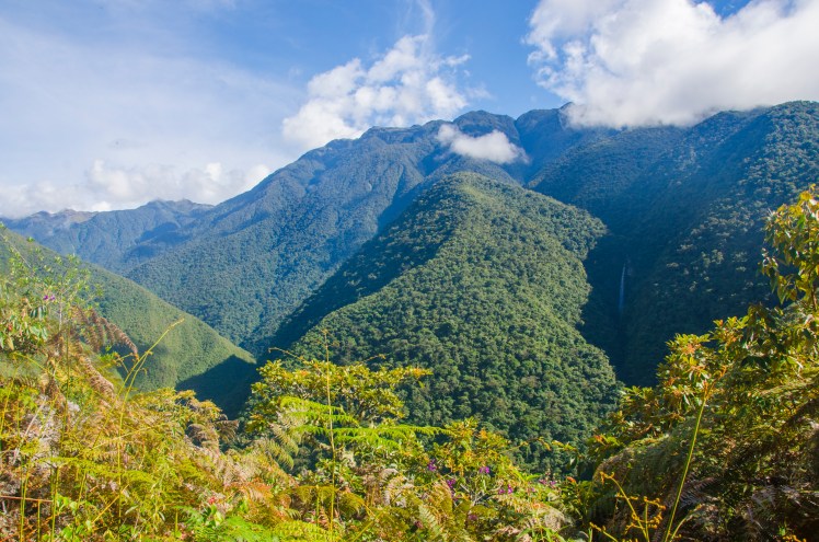
In the lower altitudes, the trail features flowing rivers, swaying suspension bridges and lush forests. Later on there are giant glaciers and emerald green lakes. But it is the mountains that are the star attraction. Four of the six highest peaks in the world are located in the area, and the Three Passes Trek gives you fantastic viewpoints of each of them. In addition, a number of smaller summits (such as Ama Dablam, Pumori and Cholatse) are just as, if not more, impressive than the 8,000m giants.
It is not just about the scenery though. The trek gives an insight into Sherpa culture, with many villages, monasteries and Buddhist monuments encountered along the way. Having said that, the popularity of Mt Everest and the EBC trail have clearly changed the lifestyle and character of these villages and the Sherpa who live there. The traditional agriculture that has dominated for centuries has greatly decreased. In its place are numerous lodges offering a large menu of delicious food and a bed for the night.
The extent of this transformation becomes clear once you step off the EBC trail, with the tourism sector less visible and agriculture more apparent. It is true, however, that the erosion of this culture has coincided with greatly improved fortunes for those who live on, or near, the EBC trail. The Khumbu Region has gone from one of the poorest in Nepal to the richest. Access to education has increased significantly.
Indeed, the younger generation of Sherpas tend to have a variety of career pathways available to them, with many attending university at various institutions across the world. However, that this was made possible by their parents and grandparents being essentially forced (due to it clearly being the highest paying occupation in the region) into dangerous work as mountain guides and porters, and far too many of them dying in the process, left me in a state of confusion about the impacts of tourism in the region. To be honest, even now I still don’t know what to think of it all.
The lodges that have taken over these villages do make the trek much more comfortable than it would otherwise be. You don’t need camping equipment or food (although some extra snacks are advisable) and the quality of bedding and dining greatly exceeded my expectations. The lodges became more basic the higher the altitude, and the additional extras (such as charging, showers, chocolate and beer) became significantly more expensive, but even the highest lodges were still far more comfortable than any night I’ve ever spent in a tent while on a trek.
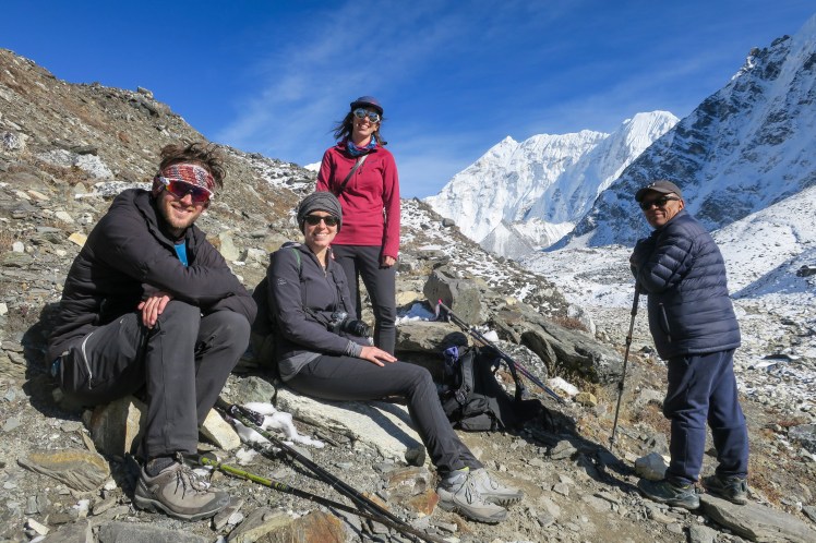
It is possible to do the trek unguided, but we were very happy with our decision to employ the services of Kaji Sherpa and his team for the trek. It was super convenient having each lodge pre-booked a day or two in advance – and we did see independent hikers having to extend their day’s walk upon learning there were no vacancies in the village they’d planned on spending the night. Kaji was also a great source of knowledge throughout the trek, constantly answering my questions on mountains and mountaineering in the region.
The trek was comfortably the longest any of us had ever done (3 weeks) and the high altitude, particularly sleeping above 4,700m from Day 9 to Day 16, took its toll. All of us developed the notorious “Khumbu Cough”, and there was some real excitement in returning to the warmer, lower altitudes by the end. But this excitement was not in any way related to the quality of the trek. Indeed, if you’re a lover of the mountains, you’d be hard pressed to find a better and more enjoyable trek anywhere in the world.
Day 1 – Lukla to Phakding
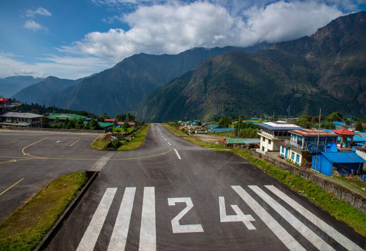
Referred to as the most dangerous airport in the world, the runway at Lukla Airport has an 11.7 per cent gradient in order to sufficiently slow down (or speed up) arriving (departing) planes.Lunch at one of the many lodges along the trek.
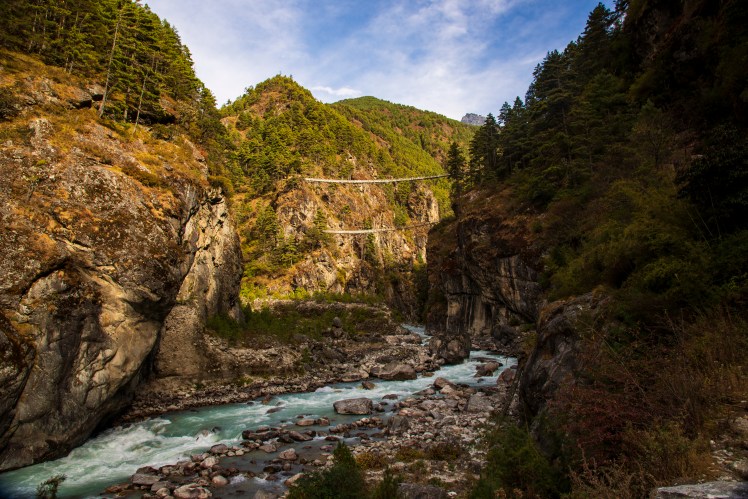
Day 2 – Phakding to Namche Bazaar
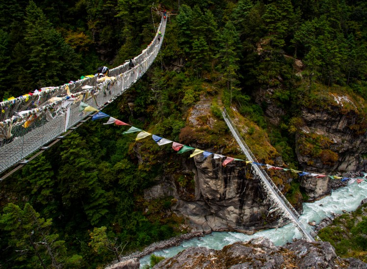
In the first two days, the Dudi Kosh river had to be crossed many times on these narrow suspension bridges. This one was so high there was another bridge visible below.
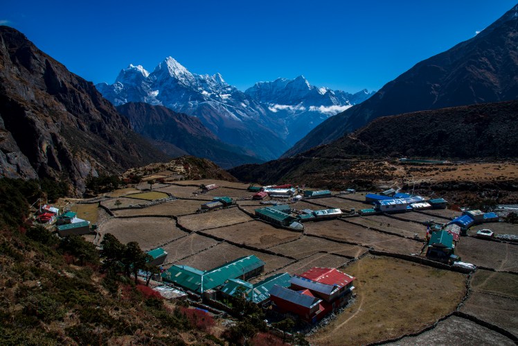
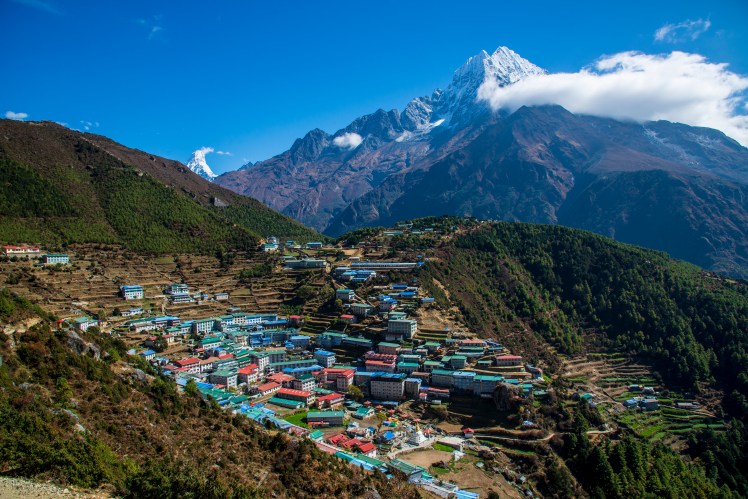
Day 3 – Namche Bazaar to Khumjung, Kunde and back to Namche Bazaar
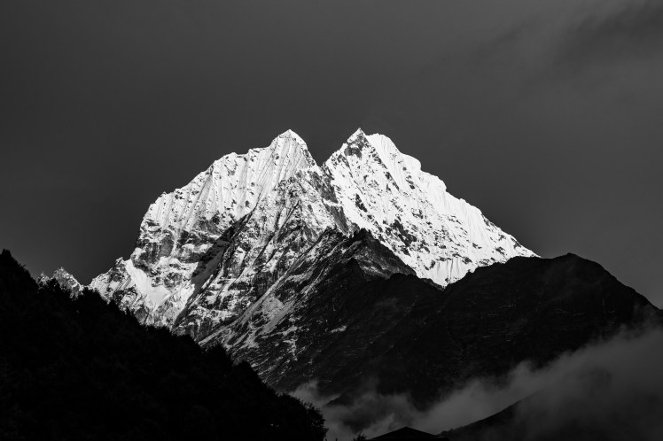
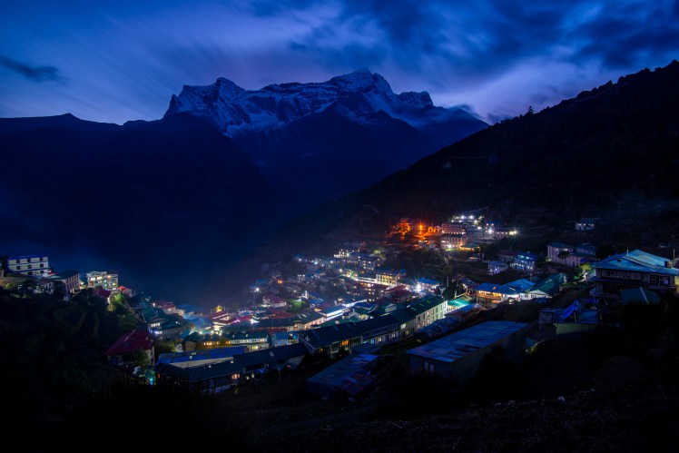
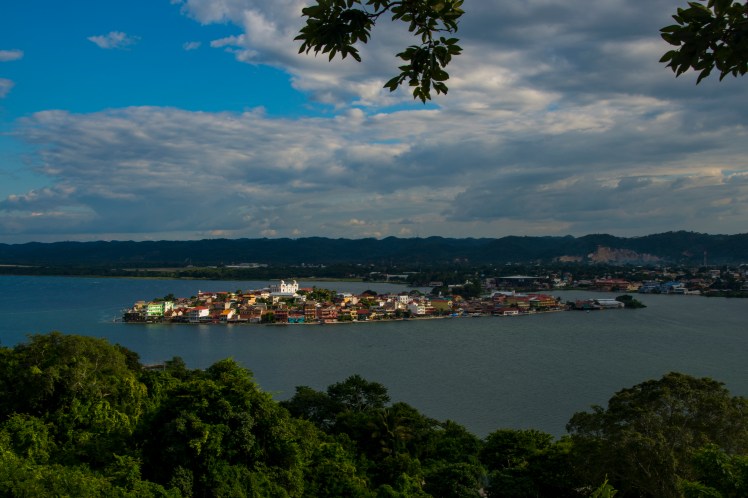
The village of Kunde that we passed through on our first acclimatisation day.The clouds cleared in the afternoon giving us some good views of the surrounding high peaks, including Thamserku (6,623m).Namche Bazaar, the biggest town in the Khumbu and one of the most dramatic locations for a settlement I’ve ever seen, built on a steep slope high above the river below, with the peaks of Thamserku, Kusum Kanguru (6,367m) and Kongde Ri (6,187m) towering above.
Day 4 – Namche Bazaar to Deboche
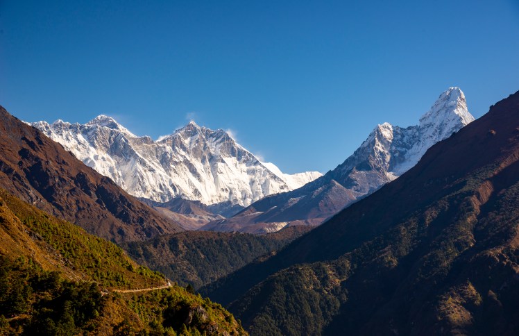
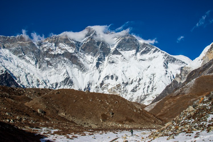
First clear morning of the trek and also our first view of Everest (8,848m, the tiny pyramid on the left), Lhotse (8,516m, the fourth highest mountain in the world and the high point on the big wall in front of Everest) and Ama Dablam (6,812m, the mountain on the right).After arriving in Deboche, we dropped off our gear and walked back up the hill to Tengboche monastery, the largest in the Khumbu and perched on a hilltop with panoramic views of the surrounding mountains.
Day 5 – Deboche to Pangboche
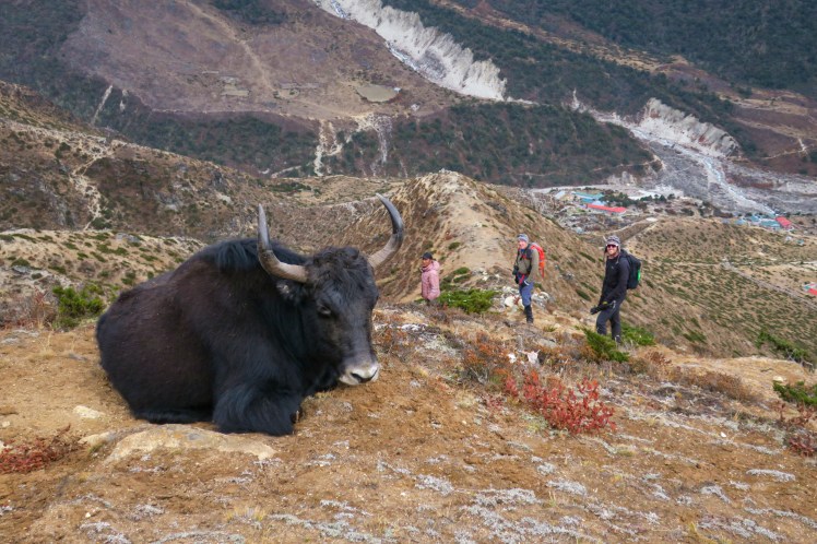
A resting Yak on a ridge above Pangboche
Day 6 – Pangboche to Ama Dablam Base Camp to Pangboche
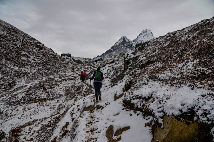
Our next acclimatisation hike was up to Ama Dablam Base Camp, with the track having just received a fresh covering of overnight snow.Ridge above Ama Dablam Base Camp. Taboche (6,542m) dominates the view, while Cho Oyu (8,201m), the sixth highest mountain in the world, is the peak covered in snow in the distance to the right of Taboche.
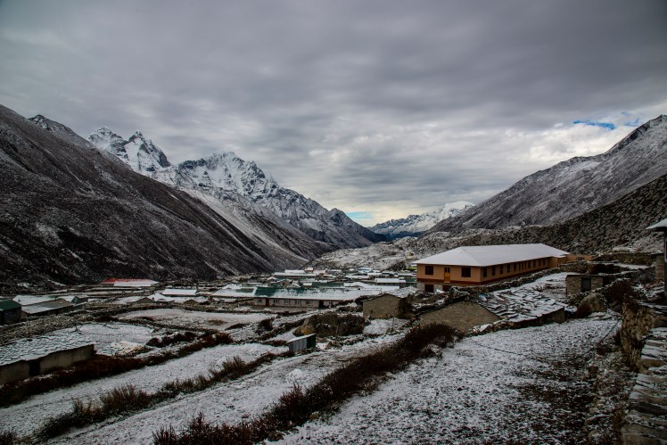
Day 7 – Pangboche to Dingboche
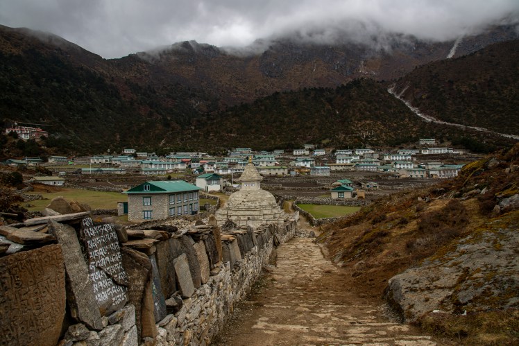
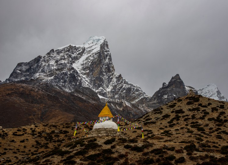
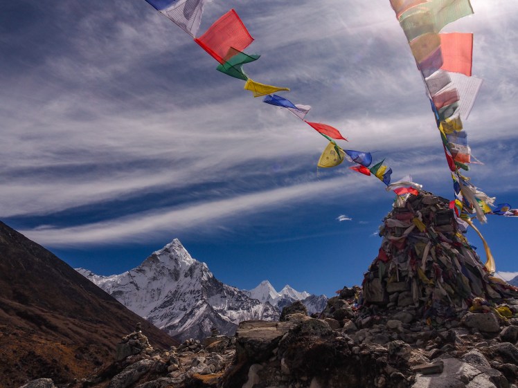
A Stupa near Dingboche. Soon after arriving in Dingboche the threatening skies became a snowstorm and we spent the rest of the day huddled around the yak dung fire in the lodge. Dingboche after the snowfall.
Day 8 – Dingboche to Nangkartshang Peak to Dingboche
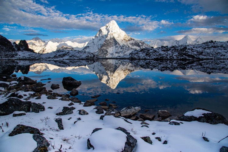
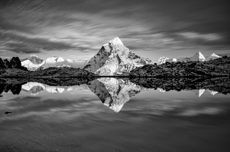
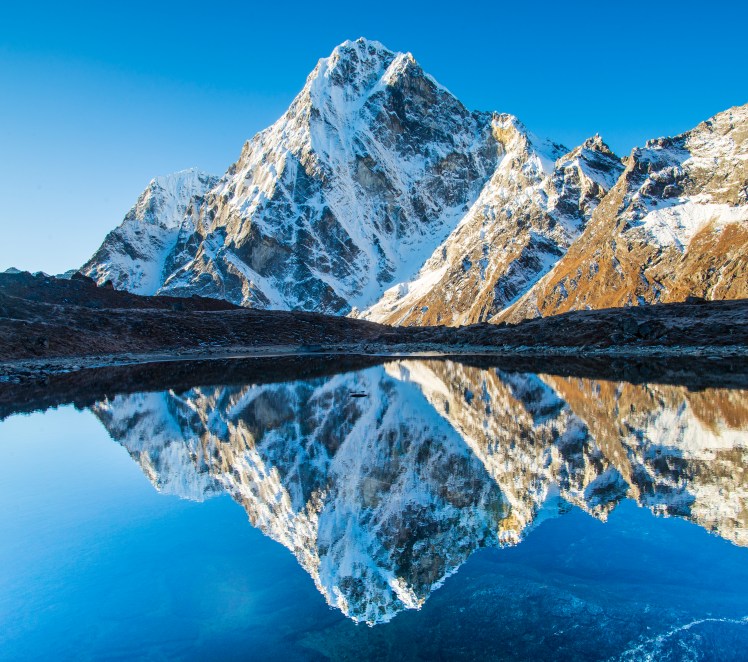
We had another acclimatisation day in Dingboche, climbing Nangkartshang Peak, which had a nice a view across the valley to Ama Dablam.That afternoon I set out on a solo trip to find a lake that I had seen American photographer Jack Brauer (mountainphotography.com) take some amazing photos from. There was no track to this lake, and I wasn’t even sure I was in the right spot, but thankfully after what felt like an endless climb I stumbled upon the lake – and for once it hadn’t clouded over in the afternoon and conditions were so calm that there was an almost perfect reflection of Ama Dablam.
Day 9 – Dingboche to Chukkung to Island Peak Base Camp to Chukkung
A break on the walk towards Island Peak Base Camp. Erin over-exerted herself and ended the day with a very nasty headache that had us wondering if we would need to descend to lower altitudes.Erin with the imposing South Face of Lhotse towering above.
Day 10 – Chukkung to Chukkung Ri to Chukkung
View from Chukkung Ri (5,546m) the highest and last of our acclimatisation walks. Makalu (8,481m), the fifth highest mountain in the world, is the rock pyramid in the distance on the left of the photo.The South Face of Lhotse and Nuptse catching the last light of the sun near Chukkung
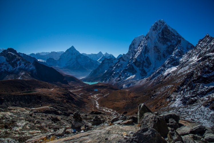
Day 11 – Chukkung to Lobuche via the Kongma La
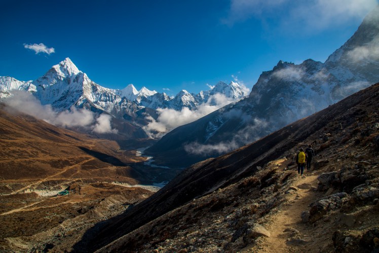
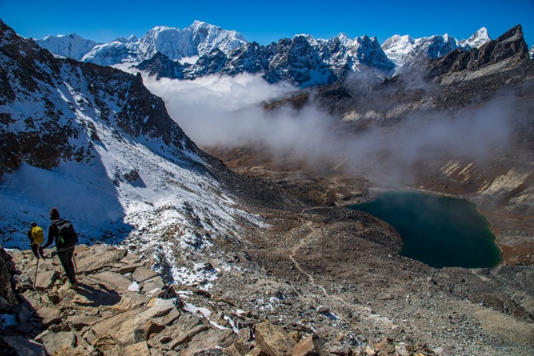
Heading over the Kongma La Pass. Unfortunately Claire and Erin were both quite sick and had to take the slightly lower Duglha Pass instead.MakaluTop of the Kongma La. From here it was a long and very steep descent before a monotonous and undulating crossing of the Khumbu glacier to reach Lobuche.While slightly lower, the Duglha Pass that Erin and Claire took was also spectacular, with great views back to Ama Dablam. It also took them past the Everest memorial, where many Stupas have been built to honour those who have lost their lives attempting to climb to the top of the world.
Day 12 – Lobuche to Gorak Shep
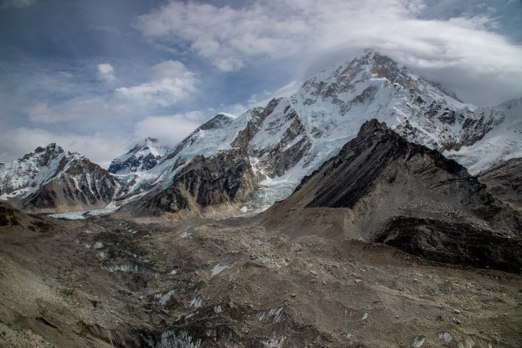
After leaving the Everest Base Camp Trail for a few days, we were back on it for the walk from Lobuche to Gorak Shep. The thin scree covered path with steep ascents and descents through the confluence of the Changri Nup and Changri Shar Glaciers created many bottlenecks, and it was slow going to get to Gorak Shep.They say in the Khumbu that you look towards Everest for the weather forecast – and sure enough not long after this cloud was brewing on the high peaks, we received heavy snowfall and spent most of the day inside and freezing cold (they don’t light the fire in the lodge we stayed in at Gorak Shep until the evening).
Day 13 – Gorak Shep to Kala Patthar to Dzongla
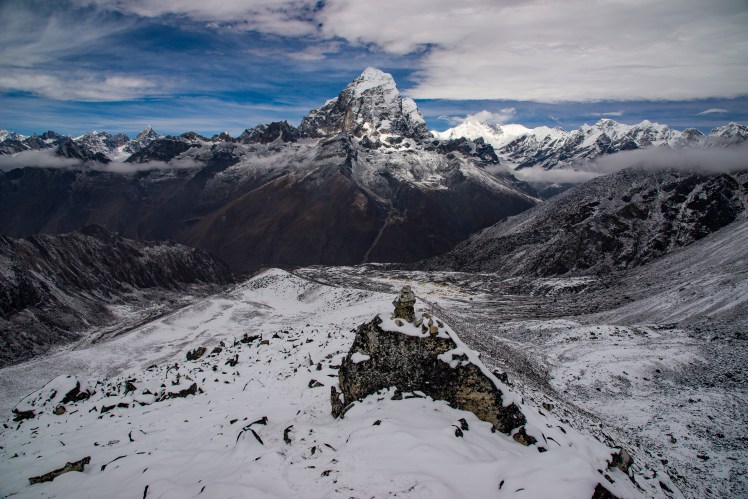
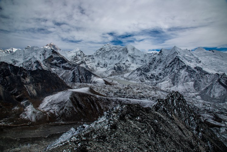
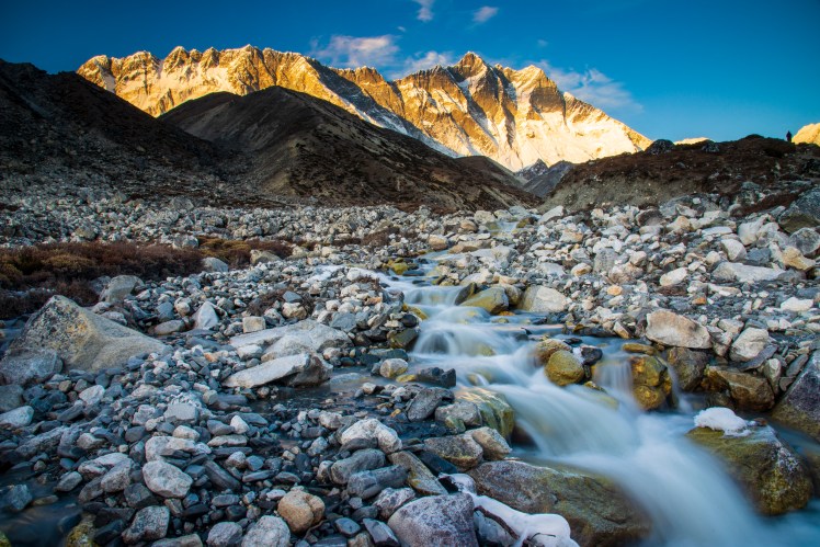
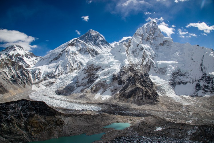
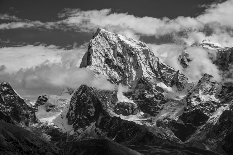
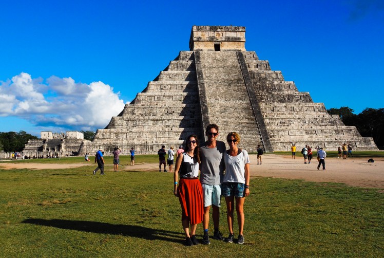
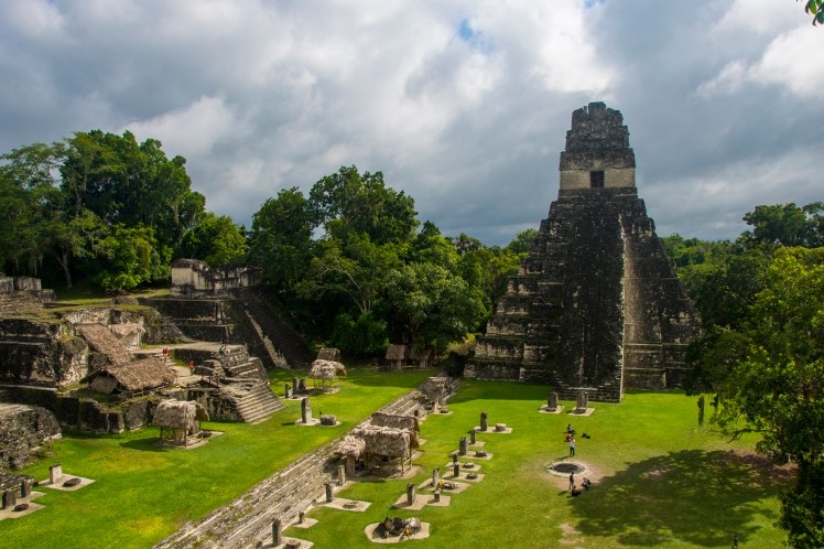
Kala Patthar, the high point of the trek (5,643m) featured an amazing view of Everest, Nuptse (to the right of Everest in the photo) and the Khumbu Icefall. Base Camp is located around the start of the Icefall, while the normal climbing route continues up the Icefall before scaling the right hand side ridge of Everest to the summit. It amazes me that people (or generally tour groups) choose to go to Base Camp instead of Kala Patthar when they only have the option of visiting one. Each to their own I guess.EverestThe section between Lobuche and Dzongla was one of the most spectacular of the entire trek, traversing high up a steep slope with views of Ama Dablam, Taboche and Cholatse (6,440m) on the other side of the valley.
Day 14 – Dzongla to Dragnag via the Cho La Pass
Early morning reflection of Cholatse. It was so cold that I had no dexterity in my fingers and ended up losing my lens cap in the lake.View back towards Dzongla while ascending the Cho La.The Cho La included a glacier crossing just before the top.
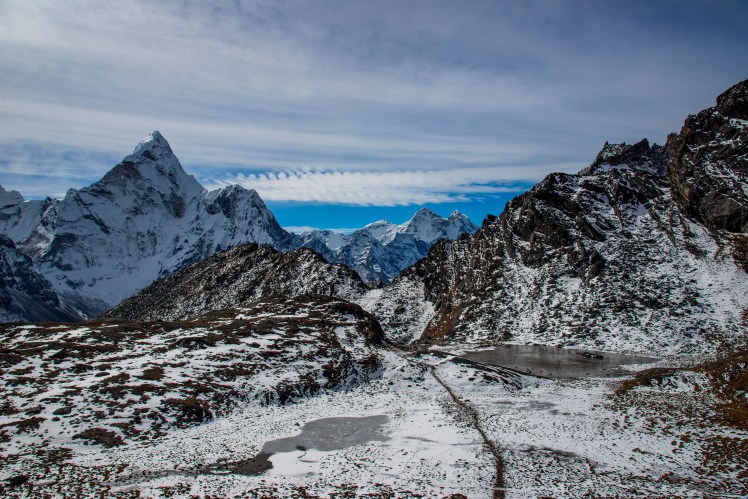
Day 15 – Dragnag to Gokyo
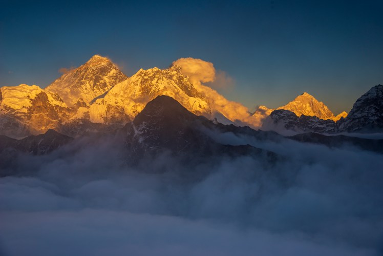
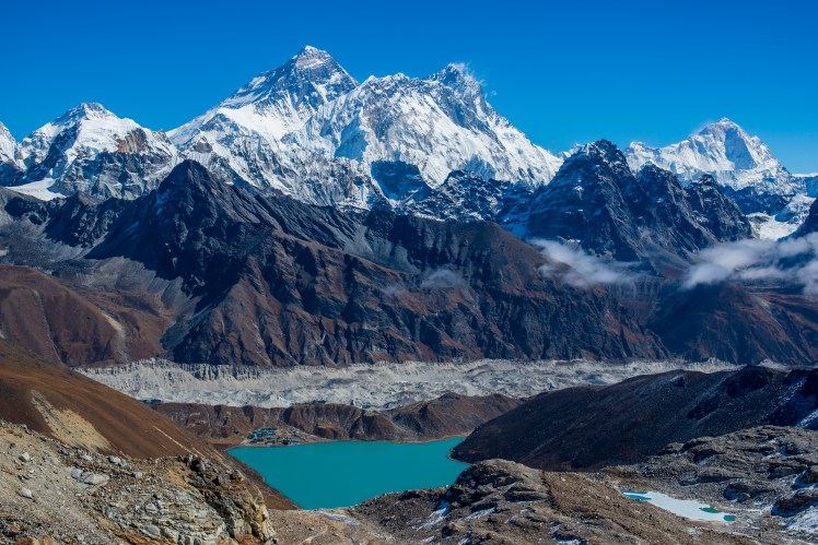
Scree covered glacier crossings, like the Ngozumpa between Dragnag and Gokyo were tedious. Very undulating and slippery underfoot.The town of Gokyo, on the shores of an emerald green lake and featuring views down the valley to Cho Oyu. The green hill with the zigzagging path leading up it is Gokyo Ri, while the path to the Renjo La (the third pass) traverses the lower slopes of Gokyo Ri and continues to the left of this picture.I climbed Gokyo Ri for sunset in the hope that it would be possible to get above the cloud that had settled over the town. This luckily proved to be true and I enjoyed a spectacular (albeit brief as it did cloud over not long after this) twilight watching the last light of the sun catch the huge peaks on the other side of the valley.Gokyo Ri is one of the few places where you can see four 8,000m peaks from the one viewpoint. Everest, Lhotse and Makalu are all pictured here.
Day 16 – Gokyo to Gokyo Ri to Gokyo
We all ascended Gokyo Ri on our second day in Gokyo. Erin here is pictured on the descent, with the Ngozumpa glacier that we crossed on day 14 running between Gokyo and the mountains behind.Cholatse
Day 17 – Gokyo to Gokyo Upper Lakes to Gokyo
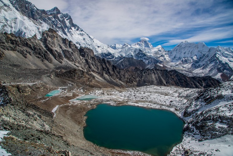
Our third day in Gokyo saw us explore the Upper Gokyo Lakes, which gave another slightly different perspective of Everest. The saddle between Everest and Lhotse (to the right of Everest) is the South Col, where the fourth (and final) camp is located for those attempting the summit.
Day 18 – Gokyo to Lunden via the Renjo La
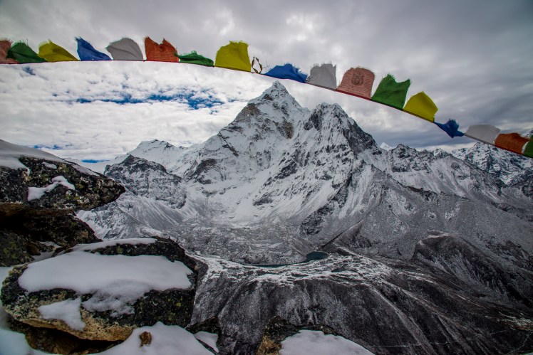
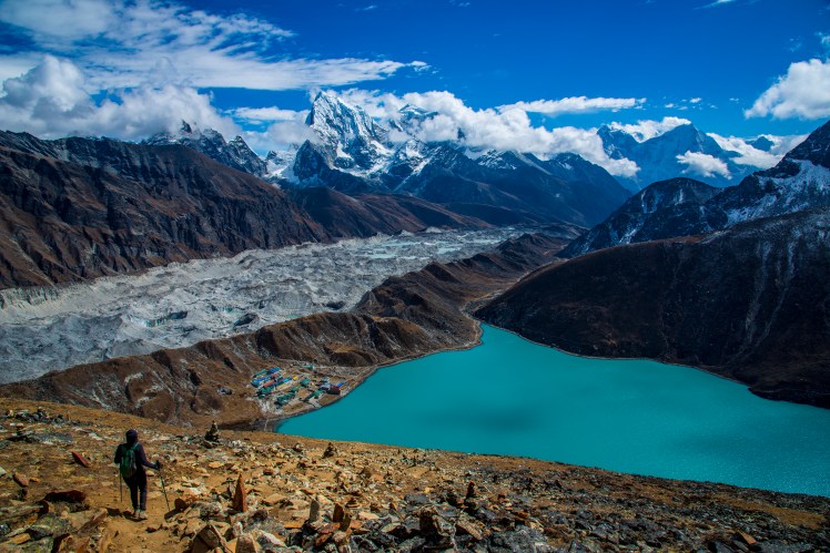
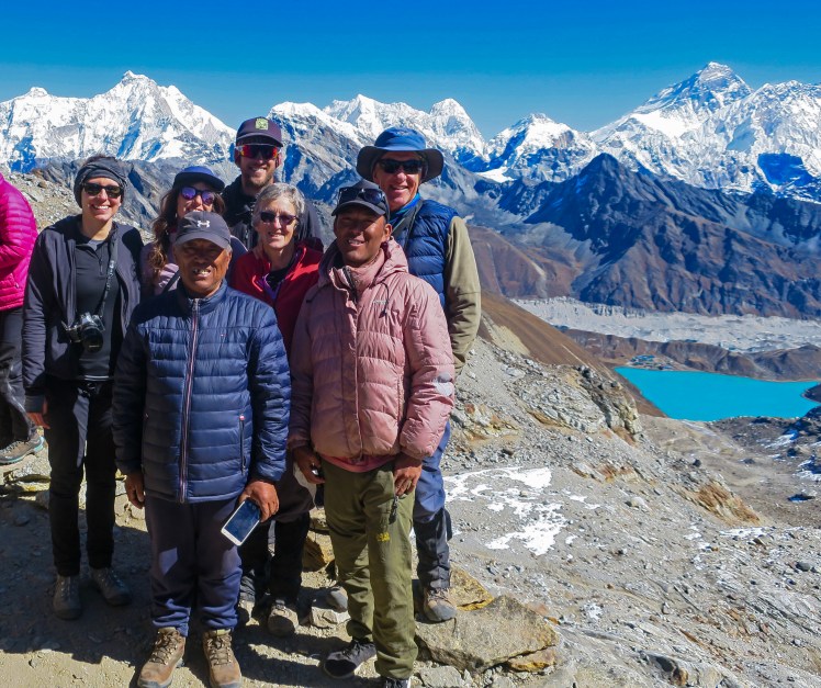
The start of the Renjo LaThe Renjo La was probably the easiest of the three big passes, although with fatigue setting in after such a long period of time at high altitude it certainly wasn’t easy. The payoff though was one of the best viewpoints of the entire trek at the top. Everest, Lhotse and Makalu in the background, with the Ngozumpa glacier and Gokyo along the shores of the emerald lake in the foreground.Kaji Sherpa (Guide), Furwa Sherpa (Assistant) and the rest of us on top of the Renjo LaDescending the Renjo La. It was pretty much downhill from here all the way to Lukla.
Day 19 – Lunden to Thame
One of the many Mani Walls during the trek.Far from the Everest Base Camp trail, Thame felt like it belonged to a different era, with fewer lodges, kids walking from neighbouring villages to school and an impressive monastery on the hill above the town.
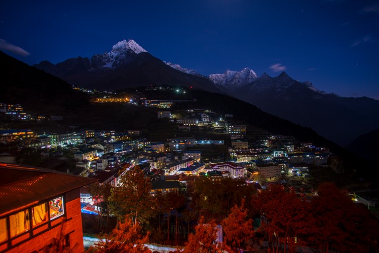
Day 20 – Thame to Namche Bazaar
Back in the familiar surrounds of Namche Bazaar. Only this time the altitude of 3,440m felt low – meaning it was time to go to the pub!
Day 21 – Namche Bazaar to Lukla
Our final day saw us walk from Namche back along the Dudi Kosh to Lukla, with familiar sights such as the double suspension bridge that we crossed on Day 2. This section of the track had taken us two days on the way up, but was easily completed in one on the return leg.Back in Kathmandu
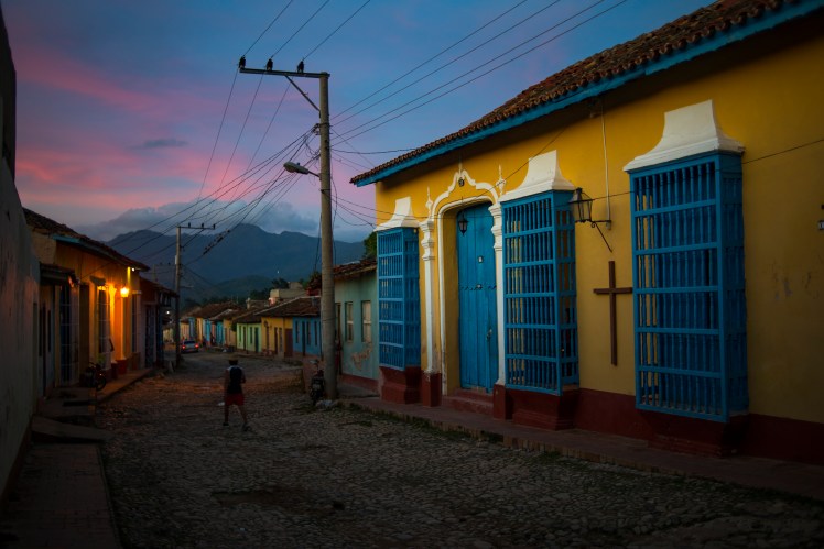
In a lot of ways, Cuba is very similar to the rest of Latin America. Spanish is the official language, albeit a shortened, fast and basically incomprehensible version. The majority of the drivers think they’re either Lewis Hamilton or Sebastian Loeb, depending on the terrain. Most aspects of life move at a slow pace, until there is a queue and all courtesy goes out the window and it’s everyone for themselves.
The way everyone spends their time relaxing outside incredibly colourful buildings could be any lowland town in Central America. Like the rest of the Caribbean, the sand is white, the waves are generally flat and the water is clear.
Playa AnconTrinidad
All the towns have beautiful central squares. Machismo culture is unfortunately all too apparent. Customer service is slow. Everyone always seems so happy. Again, this could be applied from Cuba to Chile and pretty much everywhere in between.
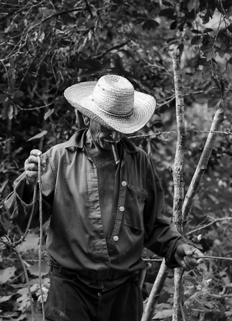
HavanaFarmer in Viñales
Very quickly though, you see things about Cuba that are very different to just about anywhere else. This first became apparent to us in the line to check in and drop off baggage for our flight. Most people were bringing back multiple air conditioning units. One guy was checking in some car tyres.
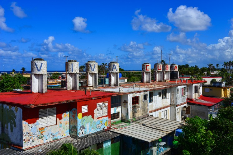
These unique views continued on arrival in Cuba. Big old American cars were common on the roads. People smoked inside. Horse drawn carts were used for non-tourist purposes. These sights made us feel like we’d been put into a time warp and sent back into the 1950s, or even earlier.
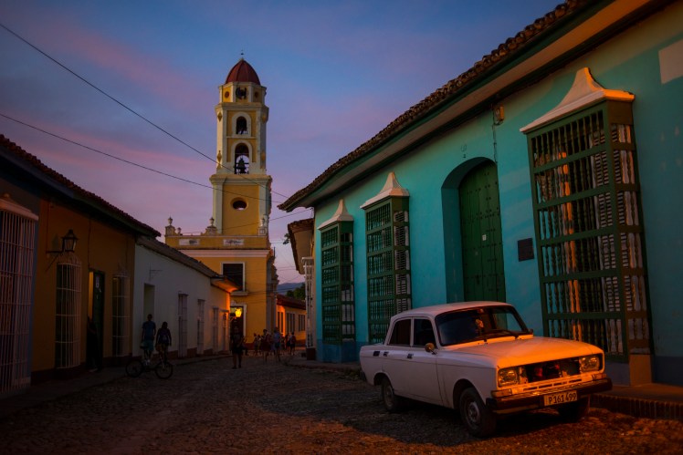
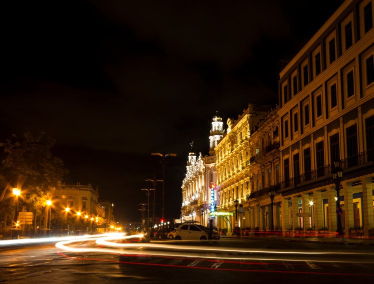
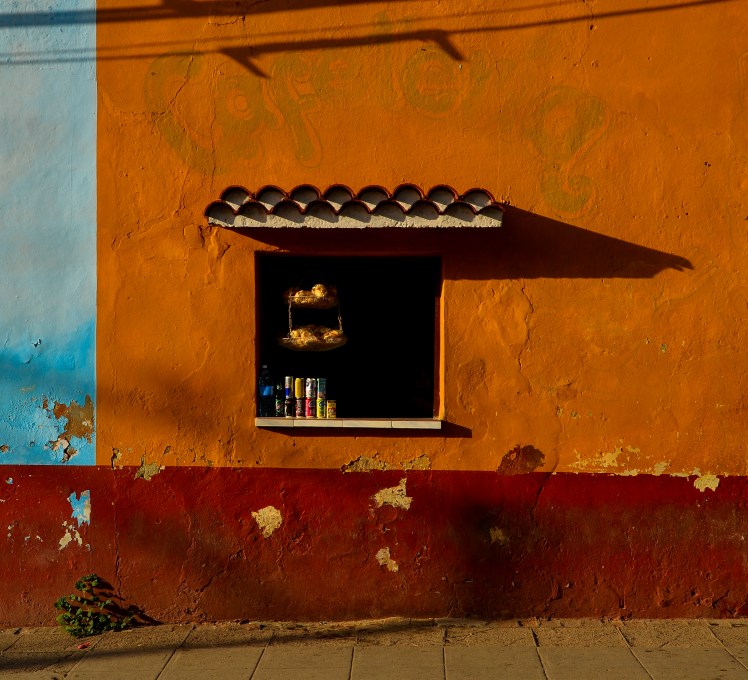
TrinidadHavana
The quality (or lack thereof) of wifi also gave us the impression of being in a time warp. The having to pay by the hour, slow speeds and limited availability were at times an annoyance (particularly when Erin was trying to organise a job interview). That one of the few places that tended to have wifi were public squares also completely changed the atmosphere in them – in Latin America public squares are great people watching areas, whereas in Cuba everyone was looking at their phone. Overall, however, the lack of wifi, combined with less options, completely simplified finding accommodation. Instead of spending half an hour on booking.com to find our next bed, we simply told our current guest house where we wanted to go, and they called a friend in that city to organise us staying there – all of which ended up being the same price.
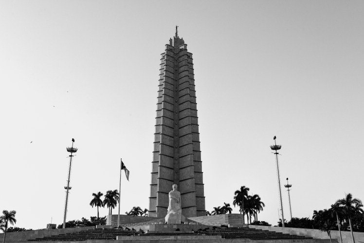
The constant propaganda was another reminder that living conditions have been a little different in Cuba than other countries we’ve visited, and also an endless source of fascination for us. There was certainly no shortage of political graffiti in other countries in Latin America, but “Evo Si” pales in comparison to big signs of Che Guevara that say “a man without blemish and fear” or regarding the US blockade “the greatest genocide of our history”.
Plaza de la Revolucion
The parts of Cuba that were completely different to other places in Latin America, let alone back home, are what make Cuba such an interesting place to visit. It meant that we spent a lot of time in Cuba just walking around the streets, with the journey towards particular locations often more interesting than the sights themselves. I sometimes think that when people say that “place x is super touristy so go to place y instead” they’re doing it to appear like a more #authentic traveller than actually believing what they’re saying – places are touristy for a reason. However, Cuba definitely challenged that point of view.
Cienfuegos
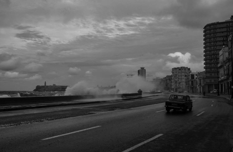
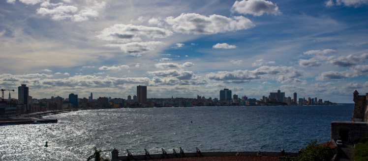
Havana waterfront
Indeed, it’s walking past games of dominoes in the street, seeing a supermarket with an entire shelf of the same brand of milk, or a huge queue outside the soap and water shop that I’ll remember most vividly about Cuba, more so than the three blocks around the Cruise Terminal in Havana Vieja being nicely restored.
That’s not to say everything that makes Cuba different is particularly enjoyable. Sometimes you don’t want to have to walk 15 minutes to get slow wifi. I get that Cuba makes nice cigars, but I didn’t need to be offered one on every street in Havana.
However, the worst part of Cuba was clearly the lack of diversity in food options. It made for some unenjoyable meals and far too much cheese pizza. I’m not sure I had a vegetable in two weeks and I felt unhealthy for most of it. Luckily after Cuba our next destination is a city famous for its healthy living and not at all for its pizza, New York…
From Flores in Guatemala, we took the chicken bus to the border and walked across in between wet season down pours. It felt very strange to be greeted by English signage at the Belizean side and I embarrassingly kept defaulting to saying gracias instead of thank you to people for the rest of the afternoon. We made our way to San Ignacio and planned to visit the ATM wet cave which contains Mayan ceramics and remains, but unfortunately it was closed the whole time we were there due to the rain. Luckily there is no shortage of ruins to visit in the area, and we chose to go to Xunantinich and Cahal Pech. It was really interesting to see more Mayan cities after having visited Tikal. From San Ignacio we travelled by bus then ferry to the island of Caye Caulker for two nights, and then San Pedro on Caye Ambergis for one night. We did a snorkelling day trip along the Belizean reef for a day from Caye Caulker and were lucky enough to see a turtle, manatees, nurse sharks, eels, lots of fish and some pretty impressive coral. It was my birthday whilst we were on these islands, which were pretty great spots to see in the big 30.
XunantunichCaye CaulkerNurse sharks on the Belizean reef
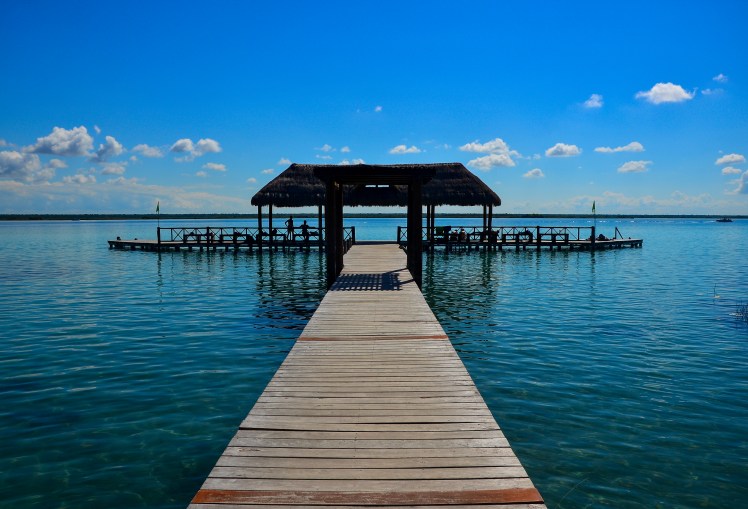
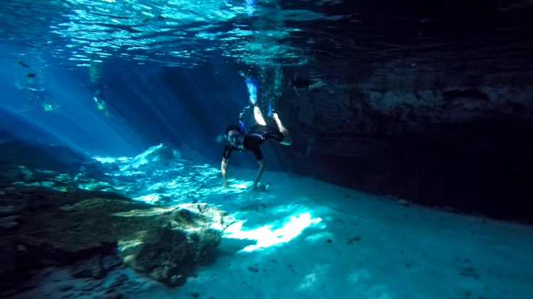
After our week in Belize we made our final land border crossing for the trip, into Mexico. Claire and Boyd were meeting us in Tulum so we spent a few nights making our way up the Yucatán Peninsula before they arrived. We stayed in a town close to the border, Chetumal, as a brief stopover before heading up to Lake Bacalar for two nights. The lake is supposedly meant to have seven shades of blue on a good day, and whilst I’m not sure about that claim, it was very beautiful nonetheless. Lake Bacalar was also where we had our first taste of Mexican ‘cenotes’, or sink holes, of which there are thousands scattered along the peninsula.
Lake BacalarLake Bacalar
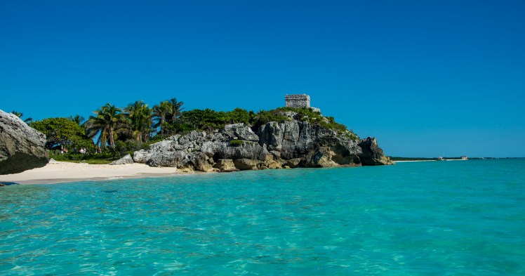
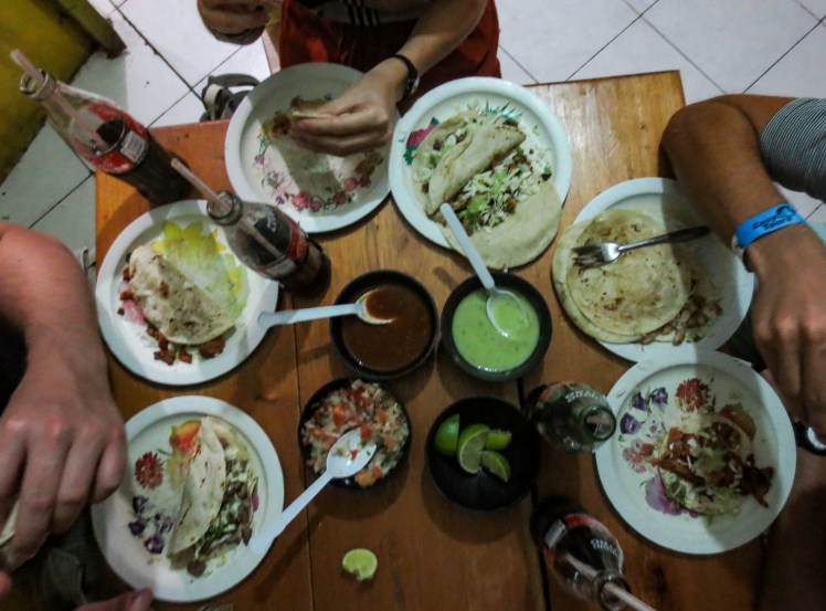
We stayed in Mahahual for the next two nights, a small town on the coast whose primary industry is most definitely tourism – cruise ships dock almost daily over the peak season. The beach there was very pretty but crowded, with each of the bars having lounges for rent right up to the waterfront. After seeing this, I expected Tulum to be similar as it is a very popular spot, but when we got there, I was amazed. The beach at Tulum was postcard perfect – fine white sand, clear turquoise water and lined with palms. There were a lot of people, but the main beach was big enough that it didn’t feel too crowded. We stayed in an Airbnb in town and tried to make our way through as many taquerias as possible in the five nights. Delicious, although Andrew and Claire both got sick towards the end. Whilst here we visited the Tulum ruins, Chichen Itza and three cenotes (Gran Cenote, Dos Ojos and Ik Kil). We snorkelled through the caves at Dos Ojos and it was incredible to see a small piece of the massive network of interconnected underwater caves. We also snorkelled off the main Tulum beach. All the snorkelling we have done on this trip has definitely made me keen to get up to QLD to see the Great Barrier Reef again before it suffers any more damage.
Tulum
Tulum Mayan ruins
Claire at Dos OjosGran CenoteIk KilChichen Itza
Tulum was stunning and I loved seeing more Mayan ruins after Guatemala and Belize. It was also really good to see Claire and Boyd. I was a little surprised at the size of the town and also how developed the tourism infrastructure was, as I had heard that Tulum was the smaller, quieter alternative to Cancun. However, after we stayed in Cancun for a night before our flight to Cuba, I saw how massive Cancun actually is and suddenly Tulum felt a lot smaller! Unfortunately as we stayed longer than anticipated in South America, we ran out of time to explore more of Mexico. Instead of rushing to cram in a few cities in the remaining time, we decided to leave the rest of Mexico to another trip. We will just have to come back for more tacos!
A number of friends of mine have completed marathons over the past few years. No matter the time, or what training program they followed, they all basically said the same thing. Around 35km into the race, they hit a big wall and the marathon started to really hurt.
I’m sure our trip has been substantially more enjoyable than the running of a marathon, but as we closed in on the 11 month mark, I started to feel like I hit a travel wall. Bewildering parts of the Latin American travel experience that months ago I would have laughed at were beginning to really annoy me. We skipped a number of popular activities because they felt like inferior versions of things we’d already done on the trip and I was more than ready to never have the same initial conversation that you have with every new person that you meet in a hostel (where are you from, how long are you travelling for, where have you been etc.)
A big part of this sudden fatigue about the trip was because I was struggling through illness at the time. In the first two weeks in Guatemala I managed to get gastro twice, conjunctivitis in both eyes and a fever, but even once I’d recovered to full health there was still an excitement whenever I thought about returning home – something that hadn’t been there previously.
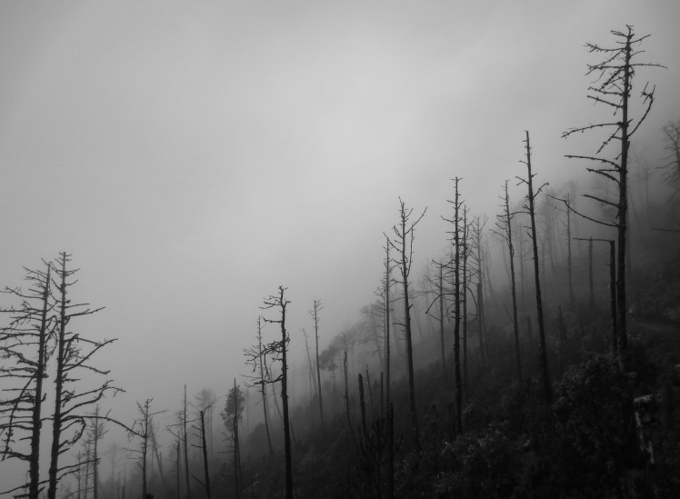
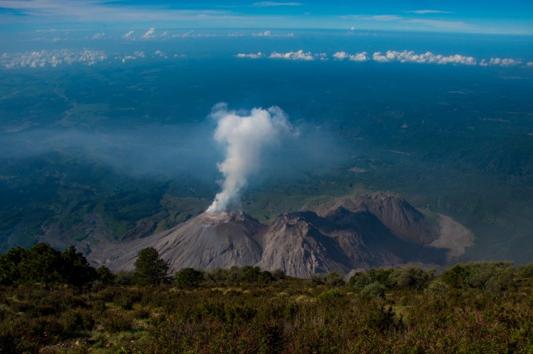
Fog on the Acatenango VolcanoSunset in Antigua
In any case, those illnesses are a form of travel fatigue themselves. In at times a desire to keep costs down, at others due to lack of options, and sometimes due to sheer laziness, we’ve had a pretty poor diet this year. Combining a lack of nutrients with being in another continent and therefore exposed to different bugs, it’s not overly surprising that we’ve both had numerous bouts with illness lately.
Despite the fatigue and illness I absolutely loved Guatemala. The country shares some similarities with Nicaragua, and either one of these two countries seem to be the favourite in Central America for a lot of travellers, making comparisons inevitable. I enjoyed Nicaragua, but was definitely team Guatemala.
Antigua
Both countries have a giant lake with great volcano views, but I preferred the stronger presence of Maya culture and cooler air at Lago Atitlan in Guatemala to humid Lago Ometepe in Nicaragua. We saw lava in both countries, but the 15 minute viewing of the Masaya crater in Nicaragua was for me easily outshone by the night spent watching regular eruptions from the Fuego Volcano in Guatemala. Both countries have nice colonial towns, although I preferred the buildings and surroundings of Antigua to those of Granada, Nicaragua. I’m happy to concede that nothing we experienced in Guatemala matched the vibrancy and revolutionary spirit of Leon, but then Guatemala has giant Maya ruins and Nicaragua does not.
Tikal
Flores
The trip to the old Maya city of Tikal was one of our highlights in Guatemala. The main plaza – with its pyramids at either end – was as spectacular as I expected, but I was completely surprised by how many pyramids have been excavated in the city and also how tall they are. The history, in particular the abandonment of the Mayan cities, is a fascinating and complex story that has been used as an example (often incorrectly) of the dangers of things such as over consumption, land degradation, over population or institutional failure.
When the Maya abandoned their big city states in the south of their empire, many of them moved to the highland areas of Guatemala. This region was also where we spent the rest of our time in Guatemala outside of Tikal. For us, after a couple of months in the sweltering and humid coastal lowland that is found across most of Central America, it was nice to have to wear trackpants and a jumper occasionally.
Aside from lower levels of sweat and itchiness, the highlands have another advantage over the lower altitudes – it was less impacted by European diseases. While in the coastal areas entire populations were nearly wiped out when the Spanish arrived, in the highlands this effect was far less pronounced. This is evident today in Andean Peru and Bolivia, where the indigenous proportion of the population is far higher than the average for the continent. It was also the case in highland Guatemala, where the Maya tradition has continued for centuries.
Unfortunately the Maya face difficulties in preserving their culture. An older Maya lady told us that men had almost entirely abandoned their traditional dress, due to discrimination in the workplace. The women spend months making skilfully designed and colourful clothing, only to then face stiff competition from cheaper (and inferior) machine made garments. The kids don’t want to learn the difficult weaving techniques that take years to master.
Lago Atitlan
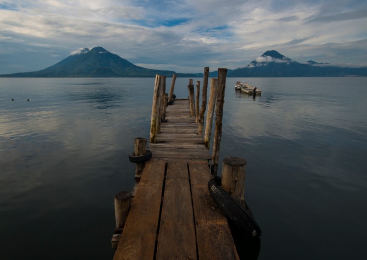
Aside from the indigenous culture, the other big attraction of the highland areas was the scenery. Bordered by three 3000m+ volcanoes, there can’t be many lakes in the world nicer than Lago Atitlan, where we spent four days exploring a number of the different towns dotted along the lakes edge.
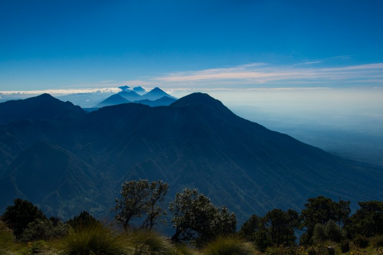
Further north, Quetzaltenango was where Erin summited her first volcano. We were rewarded with views down into an active crater below, and also volcanoes along the ring of fire stretched out in a line either side of us.
View from the Santa Maria Volcano
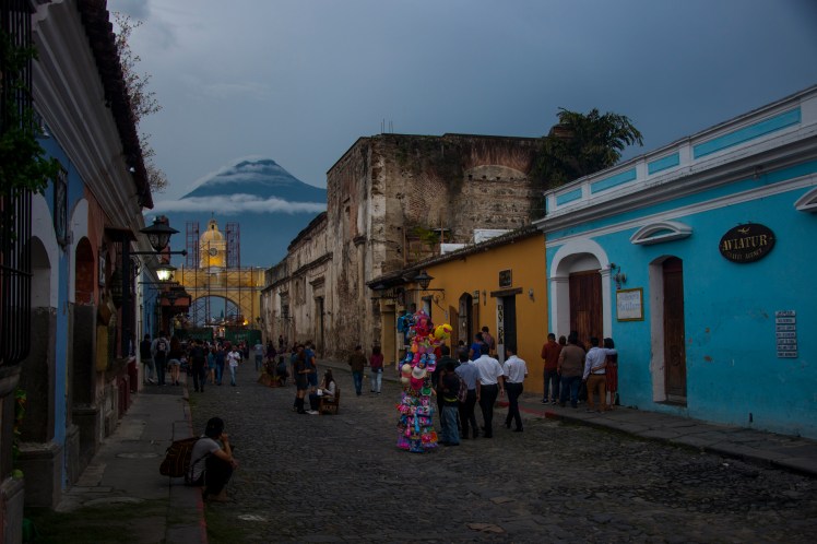
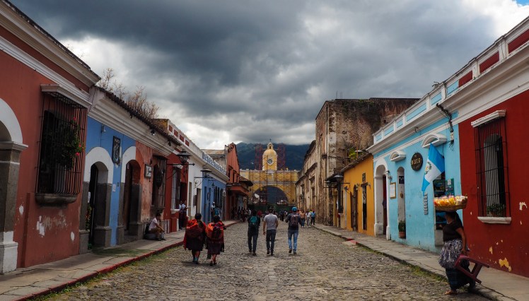
Antigua
The majority of our time in the highlands was spent in what proved to be my favourite town in Central America, Antigua. A beautifully preserved colonial town right on the foothills of the imposing Agua Volcano, it was small enough to walk everywhere but big enough to have a variety of restaurants and bars. We did a week of Spanish in Antigua, and also visited a nearby Sumpango for its Kite Festival during the Todos Los Santos celebrations (the same weekend and similar to Day of the Dead in Mexico).
Sumpango Kite Festival
However, the biggest highlight during Antigua was an overnight hike to high up Acatenango Volcano, from where we had the perfect view over the nearby and very active Fuego Volcano. We spent the afternoon and night watching the eruptions appear to change from smoke to lava as it got darker. The freezing temperatures and lack of sleep were quickly forgotten each time lava spurted out the crater in what was definitely one of my favourite nights on the entire trip.
Volcan Fuego
Indeed, Guatemala showed that the onset of some travel fatigue and a developing excitement about returning home has not dampened my enthusiasm for the high points of travel. Instead it’s the mundane aspects where my patience has completely disappeared. Luckily, with less than two months to go and still the Yucatan Peninsula, Cuba and New York to come, there should be more than enough highlights to get me through the last few remaining hostel interactions, bouts of illness and taxi drivers trying to rip us off.
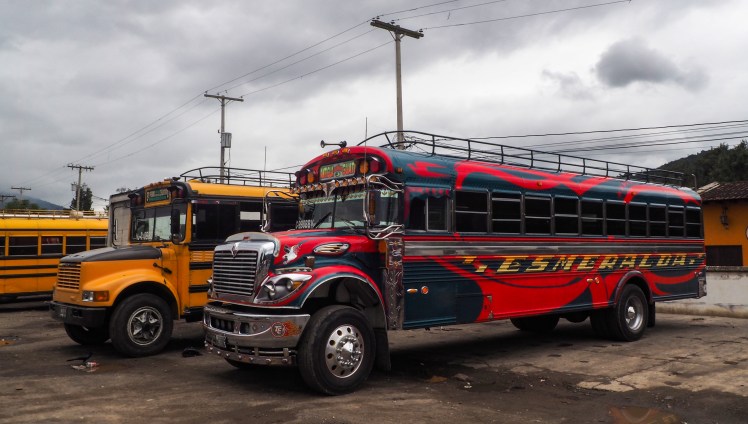
Getting from Monteverde in Costa Rica to the border with Nicaragua involved 3 different buses. We got up early and took the first one at 6am that dropped us off at the highway, then flagged down a passing bus to a town called Liberia. Once there, we hopped on the final bus to take us to the border. The border was fairly straightforward and we walked across to the Nicaraguan side. I like walking across borders, it feels a lot more satisfying than crossing in a bus for some reason. The difference between the two countries was immediately evident and the contrast reminded me of when we crossed from Argentina to Bolivia. Once through Nicaraguan immigration, we passed heckling taxi drivers into the public bus station and were hurried onto a chicken bus. Chicken buses are retired old US school buses which are now used as public buses in Central America. Some are still yellow, whilst others have been given colourful paint jobs. All feel like they could break down at any moment. As with collectivos in South America, they are operated by a driver and his helper, who shouts the destination of the bus out the front door at each stop. There are no predetermined stops, you just tell the driver when you want to hop off and they will pick up anyone who flags the bus down. If there is a maximum allowed number of passengers for the buses, it is certainly not enforced. Apparently no matter how many people there are on board, there is always room for one or two more.
Glorious chicken buses
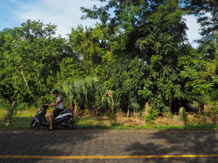
A chicken bus, taxi and ferry ride later, we arrived at Ometepe, a stunning twin volcano island in the enormous Lake Nicaragua. Concepcion is the active and more imposing of the two volcanoes, whilst Maderas lies dormant to the south. We were planning on staying two nights at each end of the island, but ended up staying four in Moyogalpa, the main town and where the ferry lands. We’d heard that bedbugs are a big problem on the island, so when after our first night we realised we had a place without them, we didn’t want to risk moving. We explored Ometepe by hiring bikes one morning, and hiring a scooter for another day. Both were great ways of seeing the island, as the buses are sporadic and taxis are expensive. Andrew climbed Concepcion one morning and afterwards we were lucky to catch the Ometepe Expo, which of course included a big parade and lots of street food. The people of Ometepe seemed so relaxed and friendly. Our trip to the museum even included a five minute break in the middle where the staff gave us a free shot of tequila, something that was very unexpected but should probably be made standard practice at all museums.
Volcan Concepcion, OmetepeHowler monkey on OmetepeOur wheels for the day on OmetepeWhen the parade passes right by your house
Top of Concepcion
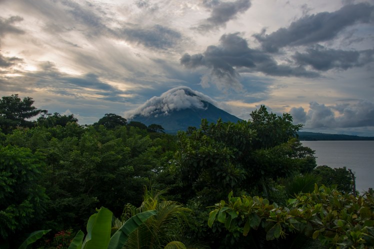
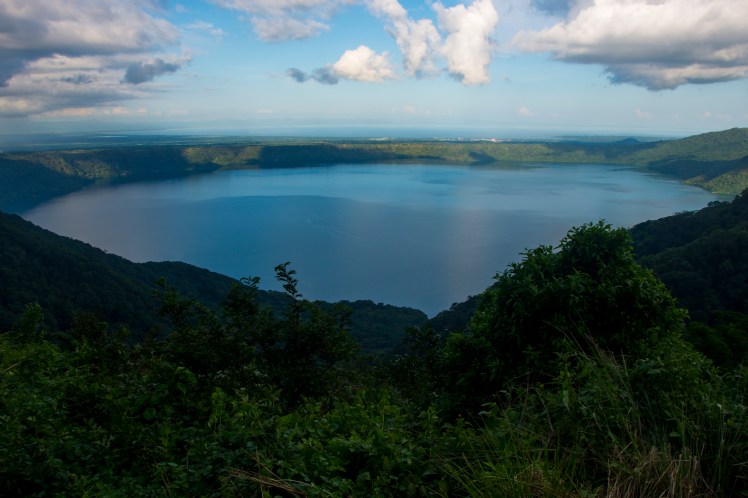
From Ometepe, we made the short trip to the colonial town of Granada, on the western shore of Lake Nicaragua. We did a week of Spanish lessons there whilst staying with the lovely family who own the school. It was a great insight into daily life in Granada. Our classes were in the mornings and during the afternoons we studied at cafes, played with the kids in our homestay and explored the city. On our free days we visited Catarina, a nearby small town with great view of Laguna de Apoyo, and Masaya, an active volcano where we saw lava for the first time! At Masaya, visits to the crater are restricted to 15 minutes and the rangers let about 70 people in at a time. The sight and sounds of the volcano were so fascinating that the 15 minutes felt like 2.
Granada
Laguna de ApoyoLava!
Tropical storm Nate hit whilst we were here, during which 43 people sadly died in Central America. We were lucky that all we experienced in Granada was a couple of days of heavy rain. The damage in the Pacific coastal town of San Juan del Sur was a lot worse. We stayed there for a couple of nights after Granada and there were many damaged sail boats stranded on the beach that had been smashed onto the sand during the storm. Some of the restaurants along the waterfront had also been hit fairly badly. We did a surfing lesson at a beginners spot just outside of town. It was fun, but I am definitely not a natural which I’m sure won’t come as a surprise to anyone.
Storm damageSan Juan del Sur
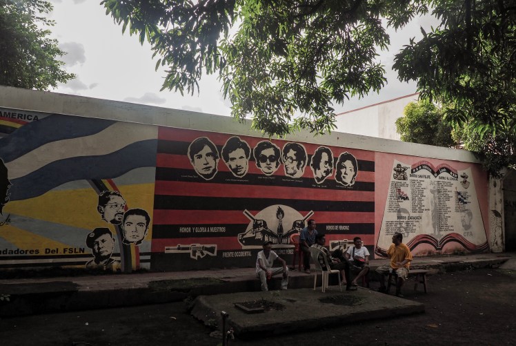
Our final three nights in Nicaragua were spent in Leon, the grungier sibling of Granada. Leon is a university town and has more restaurants and bars spread throughout the city centre than Granada, whose restaurant strip felt overly touristy with staff out the front hassling you to come in. Nicaragua’s political history is long and complicated, and Leon’s colourfully patchy colonial era facades have borne witness to their fair share of the bloodshed. The city was one of the sites of the 1979 revolution, during which the long running Somoza dictatorship was overthrown. The Somoza family had controlled Nicaragua for 43 years and three members of the family were president for 30 of these. During their reign, the illiteracy rate in Nicaragua rose to an unbelievable 50%. The rebel group FSLN was formed in 1961 by left wing ‘Sandanistas’, who aimed to end Somoza rule. The FSLN gained power after the revolution, but conflict soon returned with the start of a civil war between the government and the ‘Contras’, who were supported by some members of the Reagan administration, using funds gained from the secret sale of weapons to Iran. This was a proxy conflict of the Cold War during which the Contras committed many human rights violations and the FSLN were accused of widespread media censorship. The FSLN were voted out in 1990, however the party was re-elected in in 2007 with Daniel Ortega as their leader.
Street art in LeonParque Central, Leon
On the roof of the Cathedral, Leon
We visited the Museum of the Revolution in Leon, run by men who fought against the Somoza regime during the revolution. It was such a powerfully emotive experience listening to our guide tell the story of his involvement whilst looking at photos of Leon during the conflict, one of which he appeared in.
Staff at the Museum of the Revolution
Nicaragua was the first country in Central America where I felt we had spent a decent amount of time, and I felt that we learnt a lot more about its history than when we were passing through Costa Rica and Panama. Unfortunately, there have been recent episodes of violence in the east between the FSLN and another political party following a local election, and there are ongoing and sometimes violent land disputes between indigenous groups and farmers. The most recent national elections, whereby Ortega won his third term as president, have been heavily criticised as being fraudulent. I hope that the coming years bring more stability, and that history does not repeat itself.
For long-term travellers through Central and South America, Costa Rica and Panama tend to be seen as a bit of annoyance and many people pass through them quickly. We were told Panama is culturally uninteresting and very expensive compared with other Latin American countries and although everyone acknowledged that Costa Rica was very beautiful, people had said that it cost too much money to do anything. With this in mind, our expectations were low for this section of the trip and we decided to travel through these two countries reasonably quickly.
The two weeks we spent in Costa Rica and Panama turned out to be very enjoyable, with Costa Rica in particular being a highlight. The information we’d received before arriving in the country turned out to be somewhat true, in that activities cost more money than other places we’d been. If you wanted to involve yourself in all the zip lining, rafting and bungy swings you’d rack up a hefty credit card bill in Costa Rica fairly quickly.
Coati
Maybe it’s the fact that extreme sports don’t interest us, but we were able to still enjoy some of the amazing national parks and biodiversity that Costa Rica has to offer while also managing to stay under our budget. Aside from a quick visit to the dull capital of San Jose, we spent our time in Costa Rica in three towns bordered by nature reserves – Puerto Viejo and the nearby Cahuita reserve; La Fortuna, located at the base of the Arenal Volcano; and Monteverde.
Of these three nature areas, Cahuita was my favourite. It was a smallish jungle reserve located right on the typically beautiful Caribbean sea. Within minutes of entering the reserve, we’d already seen a parrot, toucan and some raccoons. The path hugged the coastline for several kilometres, occasionally shifting on to the beach, and if the walking became too difficult in the heat there were plenty of opportunities to swim. We ended up seeing several other animals, including a pit viper, monkeys and a coati.
RaccoonsToucanPit Viper
While not quite at the same standard as Cahuita, La Fortuna and Monteverde were both enjoyable as well. La Fortuna was named in 1968 after the Arenal Volcano erupted destroying all of the other towns located nearby. The volcano is a looming presence over the town, and although summiting the volcano is not permitted there are several different walking trails around the base. We did one tour that included some nice views of the volcano, as well as some animal and bird spotting and a visit to some natural hot springs.
La Fortuna
Monteverde is a small town in the cloud forest located near a number of different natural reserves. We decided to visit the Curi Cancha reserve, as I had heard it was the best place to see the spectacular Quetzal bird. We hired a guide, thinking that would maximise the chances of seeing the Quetzal. Unfortunately it wasn’t the correct season, but having the guide and his giant scope allowed us to see a number of birds and animals that we definitely would’ve missed if we were exploring the reserve ourselves.
Agouti
In order to stay under budget in Costa Rica, it did mean that we skipped a few activities. There were waterfalls and hikes near La Fortuna and other reserves near Monteverde and Puerto Viejo that we would’ve liked to visit. And it was very difficult to find any outdoors activities that didn’t incur a cost – even the most basic hiking trail seemed to have an entry fee or require a taxi in order to visit. But it’s hard to get too angry at a country that is choosing to preserve wilderness areas and make money from visitors as opposed to clear these areas for other economic purposes.
Like Costa Rica, I can see why people disliked Panama, but we still managed to have a good time. Panama City, with its sky scrapers and big banks, felt more like a Chinese or US city than something in Latin America. While far from a cultural experience, it was nice to stay a few days in a place that we were able to find delicious Italian food, and I was also able to buy a new camera (my other camera having died a slow and painful death one month after falling into a river Peru) at a decent price, something that would’ve been difficult in all of the other cities we’ve visited so far on this trip.
Panama City skyline
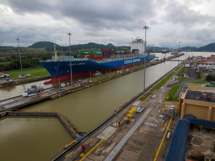
The big tourist attraction near Panama City is of course the canal. We’d been told that it wasn’t overly exciting and a bit of a tourist trap, but we ended up spending most of an afternoon there watching the container ships go through the locks. We both really enjoyed trying to work out how the ships progressed through the locks from 26m altitude at the highest point, down to the Pacific Ocean.
The other stops we had in Panama were Boquete, a town in the highland cloud forest, and Bocas Del Toro, a group of islands in the Caribbean Sea. Having low expectations and not feeling any pressure to see any “must-see” sights meant it was a very relaxing 5 days. As our trip draws towards a close we are for the first time starting to feel an element of time pressure in trying to fit in all that we want to do before we return home. But even with that pressure beginning to hover over us, it’s sometimes nice to spend a few days lying in a hammock reading a good book.
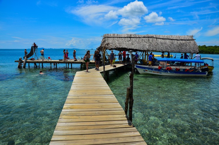
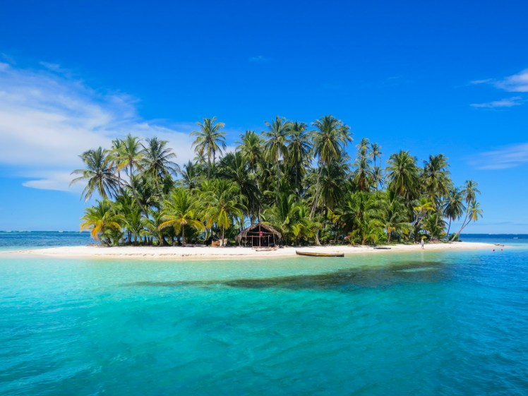
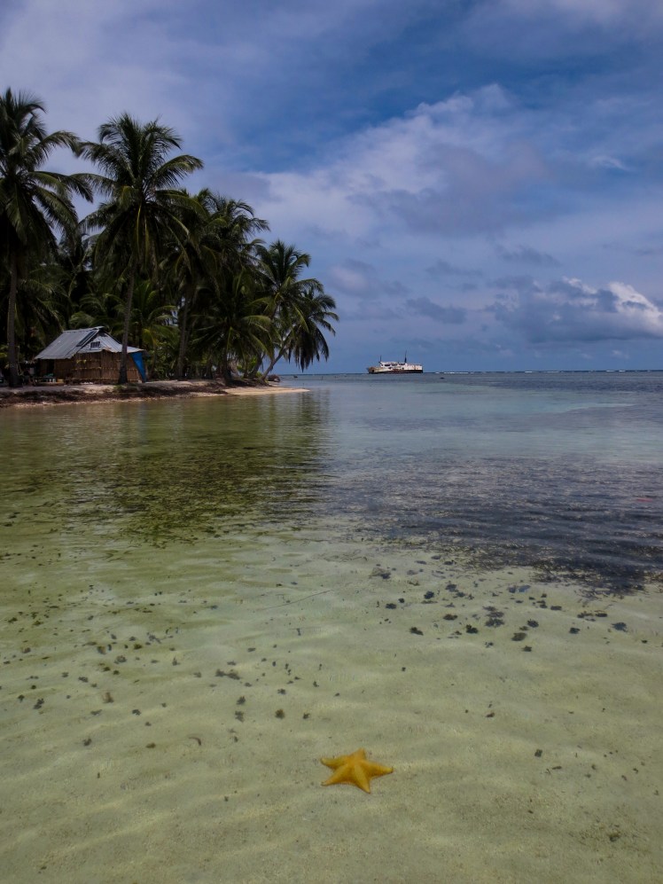
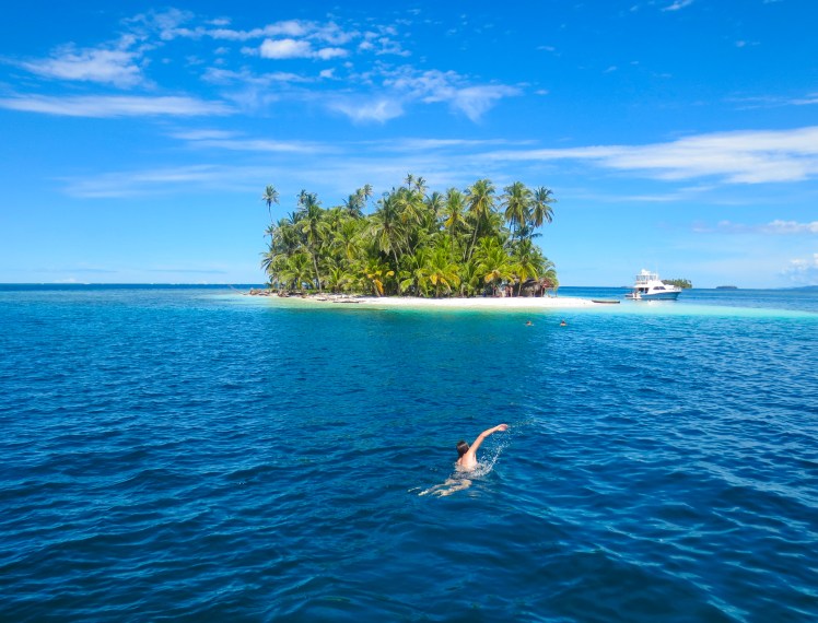
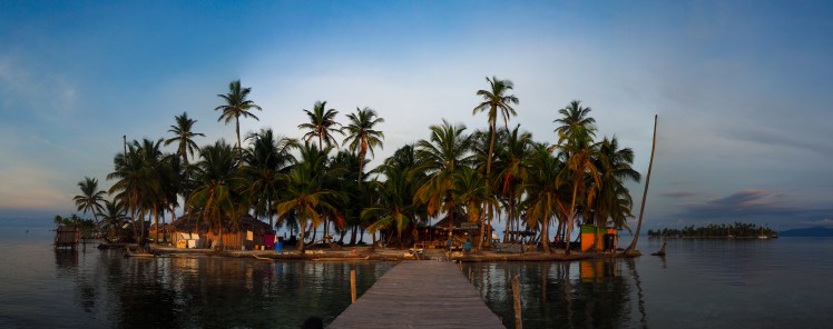
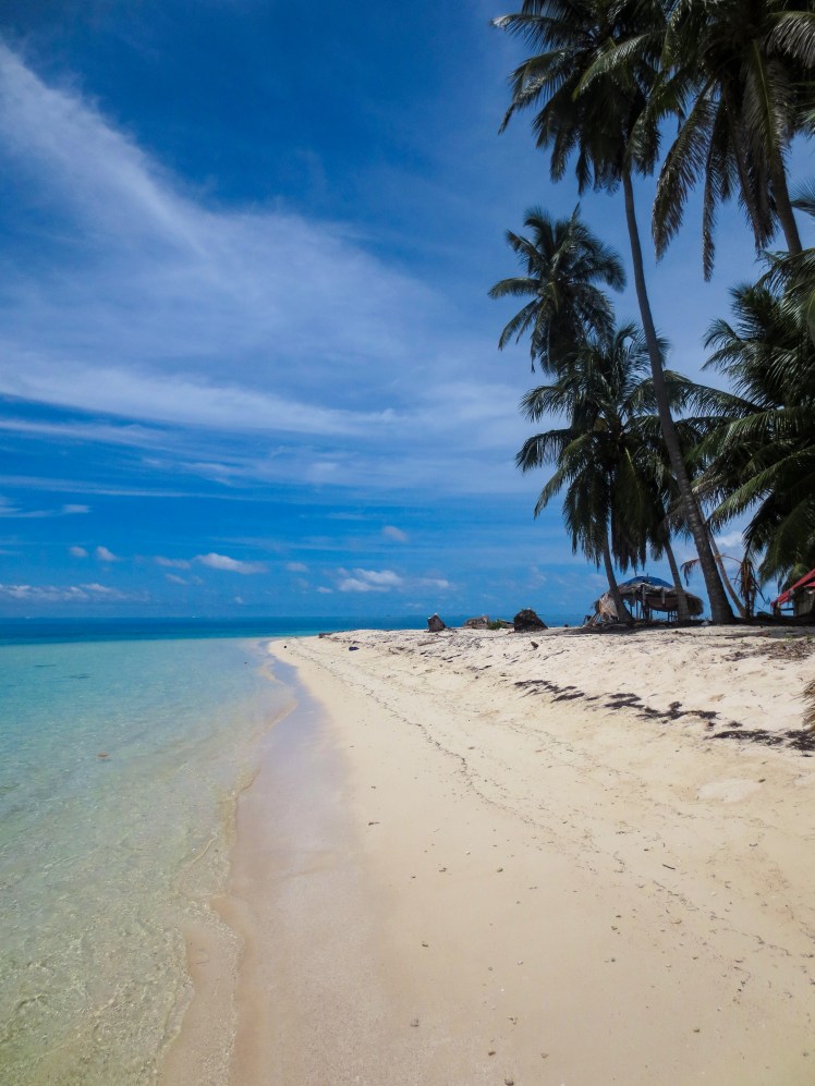
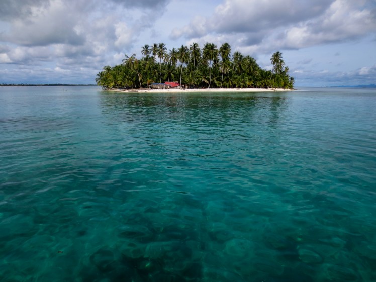
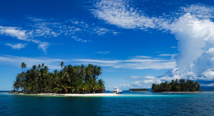
As the Darien Gap is basically unpassable, travellers need to either fly or take a boat when moving between Colombia and Panama. Sailing or speed boating via the San Blas Archipelago has become a popular way to make the most of the journey, as it is not that much more expensive than flying. The islands are home to the indigenous Guna people and of the 378 islands, 49 are populated.
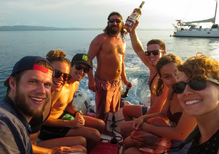
We decided to sail rather than take the speedboat as the boats leave from Cartagena (where we were), while the speedboats leave from a small town closer to the border. The trip was 5 nights, boarding on Saturday night and arriving in the islands around 2pm on Monday. We were meant to depart at 8pm, however our trip was delayed as one of the other travellers had some issues with immigration. He had entered Colombia illegally, which was strange enough in itself, but when we started talking to him whilst waiting at the port, we realised this was just the tip of the iceberg. When asked ‘where are you from?’, he replied with ‘here’, much to everyone’s confusion. He then proceeded to lecture us about his philosophies on technology and that humankind is approaching a big awakening in line with the Mayan calendar. Needless to say, none of us were too disappointed when he was unable to board.
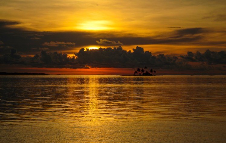
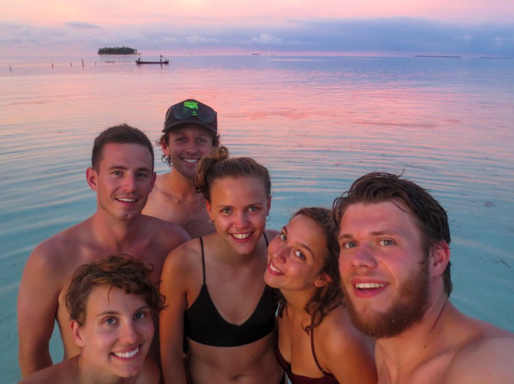
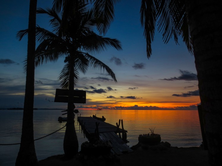
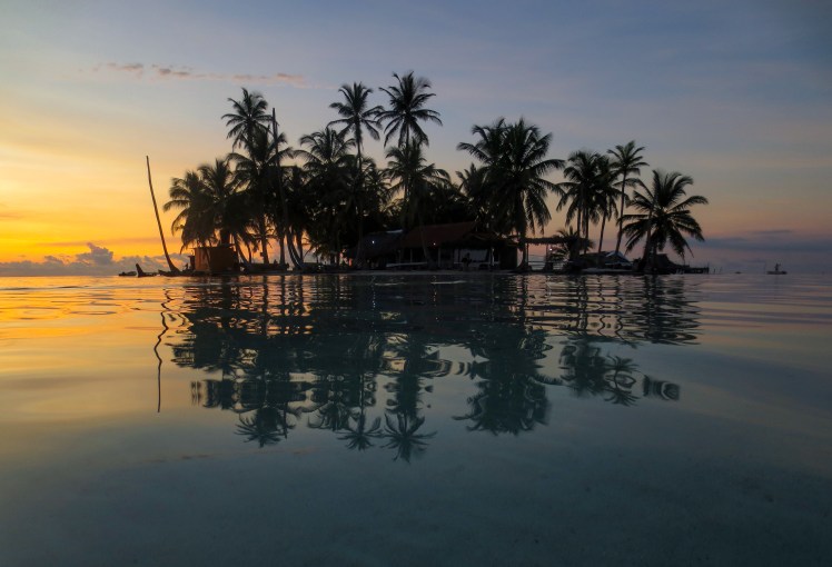
The rest of the group were great and very chilled. The boat was comfortable too, although I think it would get a little cramped if it was fully booked with 10 passengers. We had a little double cabin which was a nice bonus as we’d just booked to sleep in the salon to save money but got upgraded. The first full day was not overly fun. I was seasick and threw up four times and Andrew wasn’t feeling great either. But once we reached San Blas, it was all worth it. The first few islands that we anchored near for lunch were postcard perfect. Tiny bunches of dense palms encircled by white sand beaches and crystal clear turquoise ocean. Our days were spent snorkelling and swimming from the boat to nearby islands, sailing to a different area over lunchtime, and then repeating the morning’s activities in the afternoon. Each night, we had dinner on an island and hung out there until bedtime, which I think was perfect balance of boat and island time. On the sixth day, we were taken to the mainland and took a jeep to Panama City. The trip definitely broke the budget for a few days, but it was worth it to see scenes like this..
Overnight buses will either be freezing cold or uncomfortably warm, and there may or may not be dinner, but it will always be the opposite of what you have prepared for.
Dogs are allowed on overnight buses in Bolivia.
They will poo in the aisle, probably right next to your seats.
Buses can be up to 3 hours late with no explanation as to why.
There is no movie too violent to show on a bus.
11pm is a perfectly acceptable time to start a movie.
If multiple movies are played, Fast and Furious 8 is guaranteed.
Bus companies are more than happy to repeat the same movie in trips longer than 6 hours.
The exception to the slow pace of life in Latin America is getting on and off buses, where it is a complete frenzy.
On taxis:
Taxi drivers and tour operators who hassle tourists in the street always offer a ‘good price’.
Taxi drivers need to make sure you know they are there by not only having a taxi sign, but also flashing their lights, beeping their horn multiple times and slowing down when they pass you, even if you have already shaken your head 5 times.
After negotiating a price for a taxi in Peru, Ecuador or Colombia, there is a 90% chance that the roads are ‘very busy right now’ so the fare will have to be increased.
On accommodation:
Places that have to advertise that they have hot water generally don’t.
Gringo owned hostels have at least one gringo talking about how much local culture they’ve absorbed, how much they’ve changed, and how difficult it will be to return home.
A surprisingly high number people think cooking a gourmet meal using three of the four available hot plates is a good idea in a hostel.
Male groups are the worst dorm buddies.
It is possible to make a perfectly fine pasta meal using only a kettle.
On customer service:
The line at the supermarket will always take three times as long as you expect.
You will get served in a corner store once the attendant is ready to serve you. Facebook and key TV scenes take priority.
Despite the cash economy, no one ever has sufficient change.
Indecisiveness and hesitation turn out to be useful unintentional bargaining tools.
On fashion:
Mullets are a thing in Argentina.
Crocs are seen as a serious footwear option.
On animals:
There are some cats that even Erin won’t pat.
Stray female dogs have a lot of teats and it looks weird.
On health:
Using shampoo as body wash makes complete sense and why are they even sold as separate products?
Erin will always get 86% more bug bites than Andrew, especially beg bug bites.
Gastro symptoms come in varying and previously unexperienced forms.
There is a relationship between willingness to sample street food and time since last episode of gastro.
On each other:
Andrew will think he has lost, or will actually lose, 1-2 items per day.
Andrew will frantically and poorly search for said lost items whilst Erin watches on, bemused.
We would rather wear a t-shirt for a week straight, even in 90% humidity, than face the task of rifling through our backpacks for a fresh option.
Erin will take 4 times as long as Andrew in booking accommodation, even though she’ll end up booking the first place she looked at anyway.
Batidos (smoothies) are a perfectly acceptable meal and there is no limit on how many you should or can consume in one day.
Opening a fried chicken restaurant is always a viable business option in Peru and Bolivia, even if there are already 6 of the same type on the same street.
No matter how many carbs are already in the dish, in Bolivia there is always room for potatoes.
See #37, but replace Bolivia with Colombia and potatoes with bananas.
There is no better value than a quality $3 menu del dia.
On shopping:
There is nothing that can’t be bought at the central market.
The way candy street sellers seem to pull umbrellas out of thin air to sell as soon as it starts raining remains a mystery to us.
On culture:
There is no limit to the amount of weight a Bolivian woman can carry in the sack tied around her back.
Main squares are for sitting and watching other people. As are street front windows.
Where there are pigeons, there will be small children chasing them.
Andean kids are adorable.
You are never more than 5 days from seeing a parade.
Arriving in Santa Marta after an overnight bus from San Gil felt like we’d entered a new country. The bumpy Colombian interior had been replaced by the long flat Caribbean coastline. The jumpers and track pants went to the bottom of the bag and the shorts and thongs to the top. Reggae tunes were playing and everybody was at the beach.
The oldest city in Colombia, Santa Marta is a hole. Walking through the streets felt like you were in a place about 300 years past its prime. Most buildings were in bad need of at best a paint job and at worst a complete restoration.
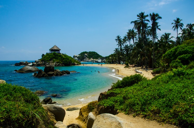
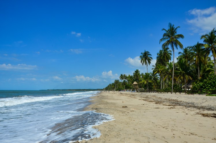
Santa Marta’s popularity on the gringo trail has nothing to do with it being the oldest city in Colombia, or it being the city where Simon Bolivar died (although there is a pretty good museum), but its location. Nearby are some of the nicest beaches on the continent. There’s also 5,000m+ peaks that can be seen from the ocean.
RodaderoRodadero Sunset
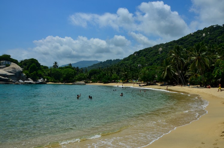
Our first two days in the Santa Marta region were spent at the resort town of Rodadero. It was an enjoyable couple of days, drinking beers on the beach and going for the odd swim to cool down. The beach experience in South America, however, is nowhere near as relaxing as in Australia. People are constantly trying to sell you stuff. Sometimes this comes in handy, like when you want to get another cold beer you don’t have to leave your seat. But the next thirty people approaching when you want nothing more than peace and quiet get pretty annoying. After two days my patience for sitting on the beach not doing much was coming to its end, and I was looking forward to heading to the nearby Tayrona National Park.
Cabo San Juan, Tayrona
I’d first heard of Tayrona when reading a book about some people who travelled through South America in the mid-1990s. They’d described it as this absolute paradise, with tropical jungle stretching all the way down to uncrowded white sand beaches. Twenty years on, it’s certainly no longer uncrowded, but the beauty of the place remains. We walked for a couple of hours into the national park and stayed two nights at Cabo San Juan, spending our days swimming, reading and exploring nearby beaches.
While in Tayrona we had two big decisions to make. The first was which campsite to stay at, and we feel like we nailed the choice of Cabo San Juan, with it being clearly the most scenic and also one of the few swimmable (there are some very strong rips along the Caribbean coast) beaches that were walking distance from the entrance. The other decision was between a hammock and a tent. Concerned about the mosquitos at night (of which there were many) we decided that a tent would be the better option. The first night was so hot that I barely slept at all. After a big afternoon storm it was a lot cooler on the second night, but our tent was completely flooded and we had a horribly uncomfortable night’s sleep on soaking mattresses.
Our next trip out of Santa Marta was to the fishing village of Palomino, home to supposedly another one of the best beaches in Colombia, where you have the possibility of viewing 5,000m+ mountains. Like Tayrona, the beach was very scenic, lined with white sand and palm trees. Like a lot of the Caribbean, the beach had a very big rip and swimming would’ve been very dangerous. The snow-capped peaks rarely emerge from the clouds. In the end we spent most of our time lounging around at the very nice hostel pool.
Palomino Beach
Our final little getaway from Santa Marta took us up into the Sierra Nevada de Santa Marta to the town of Minca, where we stayed in a sustainably run eco hostel that grew most of their own produce – that they cooked for us onsite – and featured a great view back down the hills all the way to Santa Marta. It was nice to get out of the scorching heat of the lowland areas and walk around a little, and the view from our room was fantastic. However, I did have one minor complaint with the room. It didn’t have windows. Completely open to the forest outside, we ended up having a few visitors in our room. Much to Erin’s pleasure, we had two cats that kept coming in to say hi throughout the night. A far nastier surprise was having a very poisonous snake visit us in the afternoon.
View from our hostel in Minca
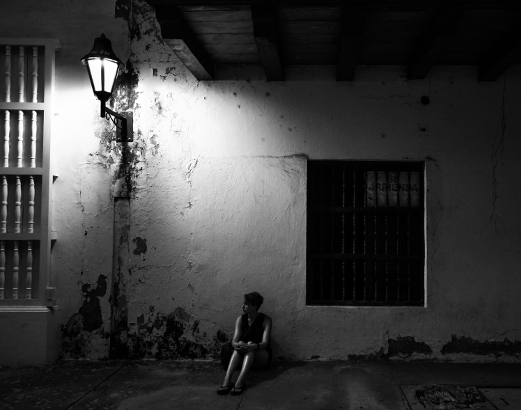
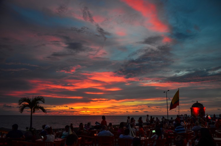
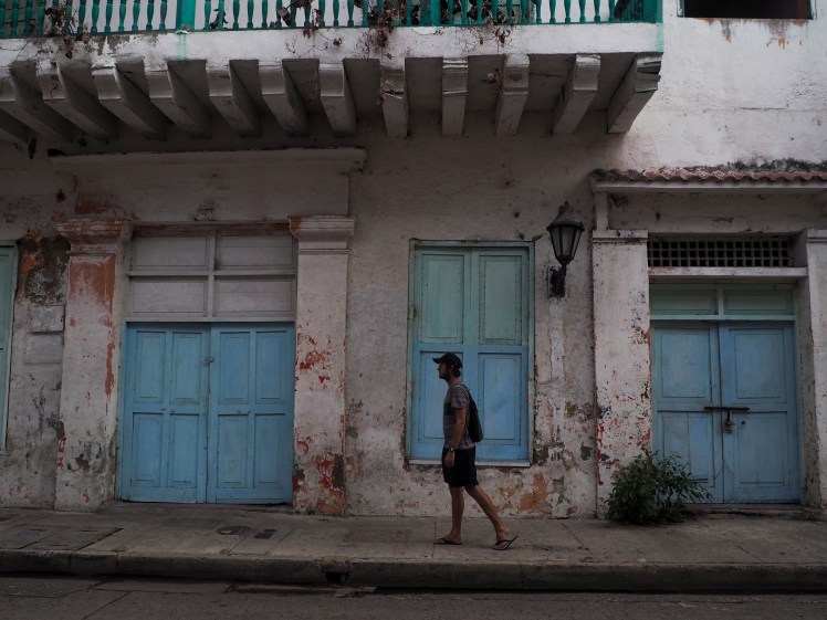
After our time in Santa Marta, we caught a bus to the jewel of the Caribbean, Cartagena. A UNESCO world heritage site, it boasts one of the best old towns not just in South America, but across the world. The old town is a decent size and every street you turn onto feels like it gets prettier and prettier.
Cartagena
Cartagena is also clearly the most popular tourist spot in Colombia. It’s the only city that seems to exist separately from the 1 to 2 month Colombian loop and is seen as a holiday destination in its own right. This not surprisingly brings with it numerous people working in the tourist industry, selling everything from city tours and traditional clothing to illicit drugs. Like Cuzco in Peru, it becomes hard to continue to appreciate the amazing architecture when you’re having to say “no gracias” every 2 minutes.
We’ve frequently used Instagram as a tool for determining where we should visit on this trip. After hearing about a place from someone else, I’m sure we’re not the only ones who have a quick look in google images to see what it looks like. Northern Colombia was, as we expected, incredibly beautiful. What we hadn’t quite anticipated was how uncomfortably hot and full of insects the region could be. You need to exercise a degree of caution when looking at images on social media, and Santa Marta and Cartagena were a timely reminder of that fact.
Leaving Barichara in Colombia meant the end of our time in the Andes. This spectacular range has been a regular presence on our trip. For our first 9 months, the most we spent outside the Andes at any one time was two weeks.
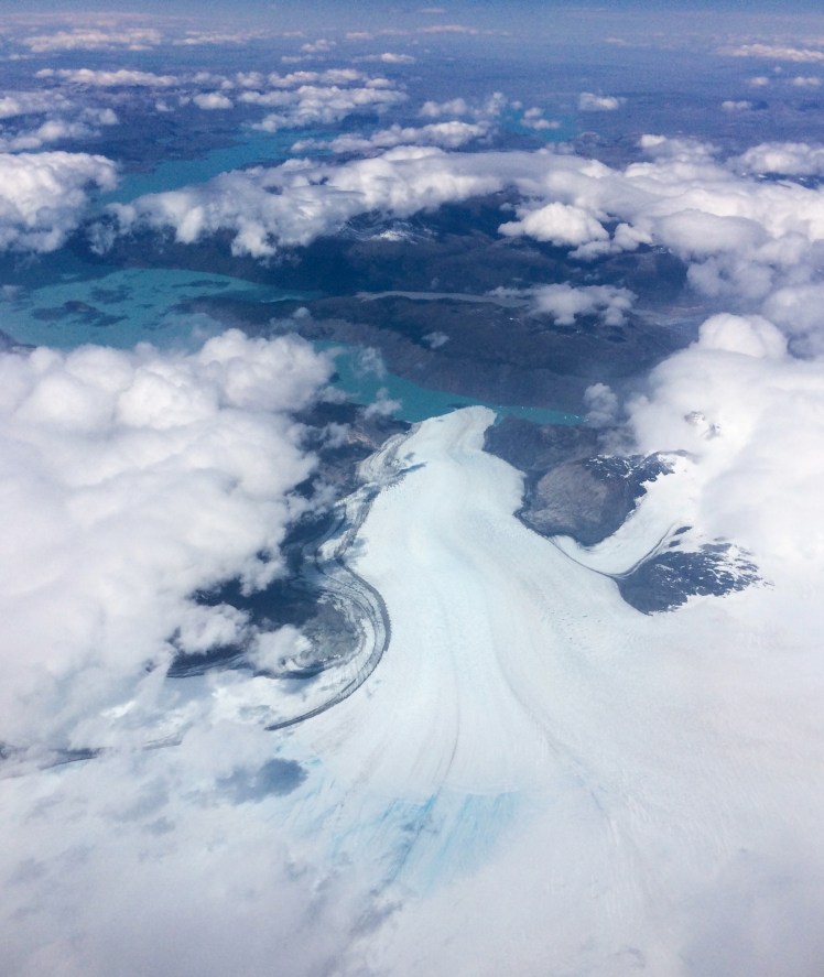
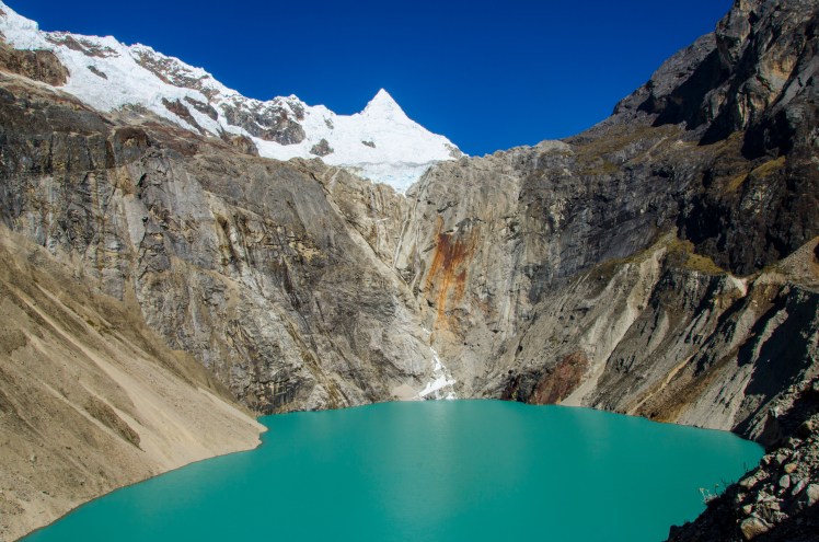
The longest mountain range in the world, running from the bottom of Patagonia up to northern Colombia, this natural barrier is a huge influence on both climate and the politics in South America. As it runs north/south, the variety of landscapes on offer are amazing. The imposing granite towers of Southern Patagonia. The Avenue of Volcanoes in Ecuador. The Salt Flats on the Bolivian Altiplano. The Blue Lakes and massive peaks of the Cordillera Blanca in Peru. All spectacular, all different and all Andean.
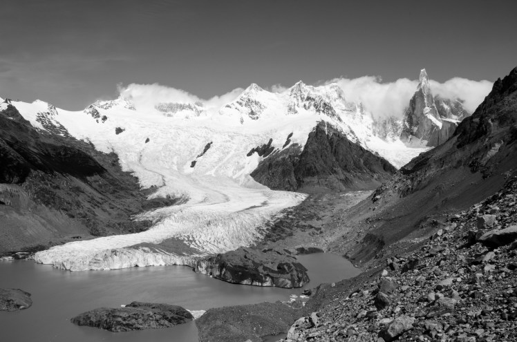
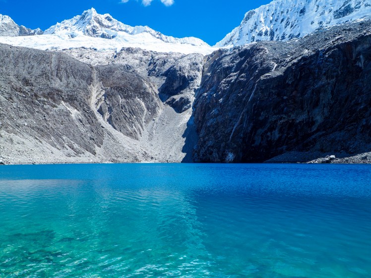
So to commemorate our final departure from this area, here is a few photos that we hadn’t yet uploaded that show the incredible scenery the Andes has to offer.
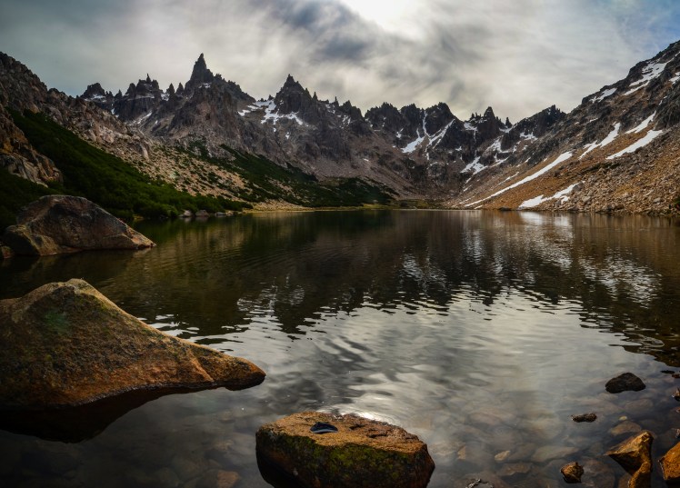
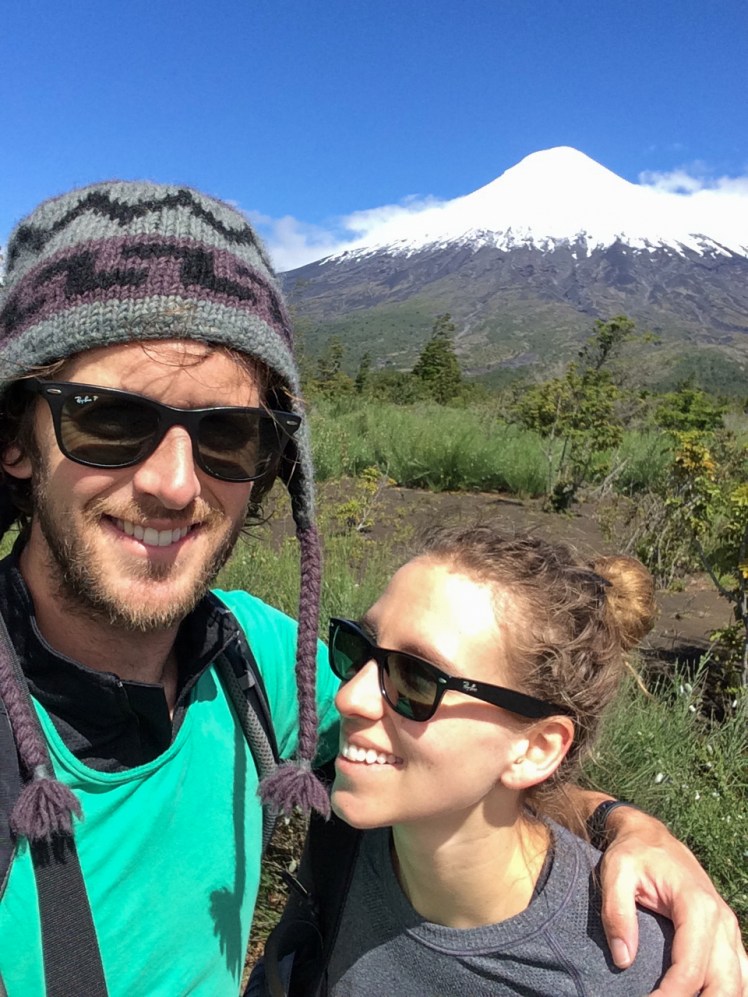
Laguna Torre, ChileLaguna 69, PeruIsla del Sol, BoliviaGlacier O’Higgins, ChileSanta Teresa, PeruValle de la Luna, ChileTorres Del Paine, ChileYungas, BoliviaPicchu Picchu, PeruLaguna Frey, ArgentinaLaguna Jancarurish, PeruChacaltaya, BoliviaLago Pehoe, ChileCotopaxi, EcuadorVolcan Osorno, Chile


You must be logged in to post a comment.